
690990688
geograf.biuro@gmail.comSzanowni klienci, w trakcie zakupów prosimy o zwrócenie uwagi na czas realizacji zamówienia poszczególnego produktu, znajdujący sie pod ceną produktu.
Kategorie
Producenci

Dodano do przechowalni


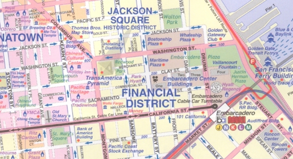
SAN FRANCISCO plan miasta 1:12 500 PÓŁNOCNA KALIFORNIA mapa ITMB

PROMOCJA: 44,90 PLN
STARA CENA: 59,90 PLN
Czas wysyłki : 24 Godziny
| Producent: ITMB - International Travel Maps |
| Kod EAN: 9781771296915 |
")
")
")
")
")
")
")
Opis przedmiotu
SAN FRANCISCO i PÓŁNOCNA KALIFORNIA
wodoodporny plan miasta i mapa regionu w skali
1:12 500 / 1:1 100 000
kanadyjskiego wydawnictwa
ITMB - International Travel Maps
This most recent edition of our popular San Francisco and region map arrives just at the start of the summer season. Sans Francisco must be one of the most interesting and livable cities in America; certainly a great favorite of mine. The entire city is shown in great detail, along with one of the special features of ITM maps the entire rapid transit system. The road network, with one-way streets is clearly shown, and as many touristic attractions as we could fit without over-crowding. The regional map covering the road network from Bakersfield north to the Oregon border has also been updated, comprising the touristic highlights : Yosemite, Death Valley, Kings Canyon, Sequoia, Redwood, Lassen National Parks, State Parks and National Forests. The map is printed on durable plastic paper with complete index of all cities and towns in the map. (Map Insets) * a map of San Francisco Bay region including access roads * a map of Bay Area Rapid Transit System This map is also available in digital format
Specyfikacja
| Autor: | praca zbiorowa |
| Producent/Wydawnictwo: | ITMB |
| Rok wydania: | 2015 |
| Kod kreskowy: | 9781771296915 |
| Skala mapy / planu miasta: | 1:12 500 / 1:1 100 000 |
| Język: | angielski |
| Ilość stron: | 2 |
| Wymiary: | 10,5 x 25 cm |
| Okładka / oprawa: | miękka wodoodporna |
| Numer wydania: | 2/3 |
-

WASZYNGTON laminowany plan miasta 1:15 000 MARCO POLO
24,90PLNDodaj do koszykadodano produktprodukt niedostępny -
Promocja P

WASZYNGTON WASHINGTON DC mapa/ plan miasta PopOut Maps
WASZYNGTON WASHINGTON DC mapa/ plan miasta PopOut Maps14,99PLNStara cena 19,99Dodaj do koszykadodano produktprodukt niedostępny -
Nowość N Promocja PPolecany P

WIELKI KANION I ARIZONA mapa ITMB 2022
WIELKI KANION I ARIZONA mapa ITMB 202254,90PLNStara cena 59,90Dodaj do koszykadodano produktprodukt niedostępny -
Promocja P

PHILADELPHIA plan miasta laminowany 1:7 000 BORCH MAP
PHILADELPHIA plan miasta laminowany 1:7 000 BORCH MAP22,90PLNStara cena 39,90Dodaj do koszykadodano produktprodukt niedostępny -
Promocja P

CHICAGO plan miasta laminowany 1:8 000 BORCH MAP
CHICAGO plan miasta laminowany 1:8 000 BORCH MAP19,90PLNStara cena 39,90Dodaj do koszykadodano produktprodukt niedostępny -

LAS VEGAS mapa/ plan miasta PopOut Map
19,99PLNDodaj do koszykadodano produktprodukt niedostępny -

CHICAGO mapa/ plan miasta PopOut Maps
19,99PLNDodaj do koszykadodano produktprodukt niedostępny -
Promocja P

MIAMI mapa/ plan miasta PopOut Maps
MIAMI mapa/ plan miasta PopOut Maps14,99PLNStara cena 19,99Dodaj do koszykadodano produktprodukt niedostępny -
Promocja PPolecany P

MANHATTAN 1:12 500 STAN NOWY JORK 1:1 000 000 mapa ITMB
MANHATTAN 1:12 500 STAN NOWY JORK 1:1 000 000 mapa ITMB54,90PLNStara cena 59,90Dodaj do koszykadodano produktprodukt niedostępny -

LAS VEGAS - NEVADA plan miasta UNIVERSALMAP
26,90PLNDodaj do koszykadodano produktprodukt niedostępny -
Promocja PPolecany P

MIAMI I PD FLORYDA plan miasta 1:12 500 / 1:400 000 ITMB - International Travel Maps
MIAMI I PD FLORYDA plan miasta 1:12 500 / 1:400 000 ITMB - International Travel Maps46,90PLNStara cena 59,90Dodaj do koszykadodano produktprodukt niedostępny -

MANHATTAN plan miasta laminowany 1:15 000 wyd. BORCH
24,90PLNDodaj do koszykadodano produktprodukt niedostępny -
Promocja PPolecany P

TEXAS I OKLAHOMA mapa wodoodporna ITMB
TEXAS I OKLAHOMA mapa wodoodporna ITMB49,90PLNStara cena 59,90Dodaj do koszykadodano produktprodukt niedostępny -
Promocja PPolecany P

PHILADELPHIA mapa / plan miasta PopOut Maps
PHILADELPHIA mapa / plan miasta PopOut Maps16,99PLNStara cena 19,99Dodaj do koszykadodano produktprodukt niedostępny -

PHOENIX plan miasta laminowany 1:20 000 / 1:105 000 BORCH
24,90PLNDodaj do koszykadodano produktprodukt niedostępny -
Nowość N Promocja PPolecany P

HONOLULU I OAHU mapa wodoodporna ITMB 2022
HONOLULU I OAHU mapa wodoodporna ITMB 202254,90PLNStara cena 59,90Dodaj do koszykadodano produktprodukt niedostępny -

BOSTON plan miasta laminowany 1:15 000 MARCO POLO
21,90PLNDodaj do koszykadodano produktprodukt niedostępny -

SEATTLE - WASHINGTON plan miasta UNIVERSALMAP USA
24,90PLNDodaj do koszykadodano produktprodukt niedostępny -
Promocja P

CHICAGO mapa laminowana 1:9 000 BERNDTSONMAP
CHICAGO mapa laminowana 1:9 000 BERNDTSONMAP34,90PLNStara cena 44,90Dodaj do koszykadodano produktprodukt niedostępny -
Nowość N Promocja PPolecany P

NOWY ORLEAN / RZEKA MISSISSIPPI mapa ITMB 2022
NOWY ORLEAN / RZEKA MISSISSIPPI mapa ITMB 202254,90PLNStara cena 59,90Dodaj do koszykadodano produktprodukt niedostępny -
 plan miasta UNIVERSALMAP")
INDIANAPOLIS (INDIANA) plan miasta UNIVERSALMAP
25,90PLNDodaj do koszykadodano produktprodukt niedostępny -
Promocja P

WASZYNGTON plan miasta 1:12 000 MICHELIN
WASZYNGTON plan miasta 1:12 000 MICHELIN26,90PLNStara cena 39,90Dodaj do koszykadodano produktprodukt niedostępny -

SEATTLE plan miasta laminowany 1:10 000 wyd. BORCH MAPS
29,90PLNDodaj do koszykadodano produktprodukt niedostępny -

NOWY ORLEAN mapa/ plan miasta PopOut Maps
NOWY ORLEAN mapa/ plan miasta PopOut Maps19,99PLNDodaj do koszykadodano produktprodukt niedostępny -

BOSTON mapa/ plan miasta PopOut Maps
19,99PLNDodaj do koszykadodano produktprodukt niedostępny -
Promocja PPolecany P

NEW YORK CITY / NOWY JORK plan miasta laminowany 1:15 000 BORCH 2020
NEW YORK CITY / NOWY JORK plan miasta laminowany 1:15 000 BORCH 202039,90PLNStara cena 44,90Dodaj do koszykadodano produktprodukt niedostępny -
Promocja PPolecany P

CHICAGO I JEZIORO MICHIGAN mapa ITMB
CHICAGO I JEZIORO MICHIGAN mapa ITMB44,90PLNStara cena 59,90Dodaj do koszykadodano produktprodukt niedostępny -

PHILADELPHIA - PENSYLWANIA plan miasta UNIVERSALMAP
PHILADELPHIA - PENSYLWANIA plan miasta UNIVERSALMAP24,90PLNDodaj do koszykadodano produktprodukt niedostępny -

BALTIMORE - MARYLAND plan miasta UNIVERSALMAP USA
26,90PLNDodaj do koszykadodano produktprodukt niedostępny -
Nowość N Promocja PPolecany P

NOWY MEKSYK I ARIZONA mapa ITMB 2022
NOWY MEKSYK I ARIZONA mapa ITMB 202254,90PLNStara cena 59,90Dodaj do koszykadodano produktprodukt niedostępny