
690990688
geograf.biuro@gmail.comSzanowni klienci, w trakcie zakupów prosimy o zwrócenie uwagi na czas realizacji zamówienia poszczególnego produktu, znajdujący sie pod ceną produktu.
Kategorie
Producenci


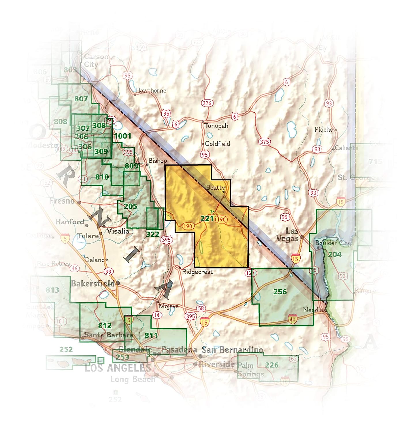
Death Valley National Park mapa wodoodporna NATIONAL GEOGRAPHIC 2022

| Producent: NATIONAL GEOGRAPHIC |
| Kod EAN: 9781566953214 |
")
")
")
")
")
")
DEATH VALLEY
National Park
TRAILS ILLUSTRATED MAPPARK NARODOWY YELLOWSTONE
Składana, wodoodporna mapa turystyczna wydana przez
NATIONAL GEOGRAPHIC
w skali 1:165 000
numer mapy 221
- Waterproof - Tear-Resistant - Topographic Map
Despite its foreboding name and the fact that it is the hottest, lowest, and driest area in North America, Death Valley National Park maintains a great diversity of life in its dramatic terrain of salt-flats, canyons, mountains, valleys, sand dunes, and badlands. National Geographic's Trails Illustrated map of Death Valley National Park delivers unmatched detail and valuable information to assist you in your visit to this land of extremes. Expertly researched and created in partnership with local land management agencies, this map features key areas of interest including Badwater Basin, Furnace Creek, Scotty's Castle, Panamint Springs, and Stovepipe Wells.

With miles of clearly marked trails that include mileages between intersections, this map will prove invaluable in your exploration of the park. A list of backcountry roads and trails complete with descriptions, lengths, and starting points will help you choose a route that's right for your activity level and recreation use. The map base includes contour lines and elevations for summits. Hot weather tips, a temperature chart, regulations, and safety suggestions are included as well.


Every Trails Illustrated map is printed on Backcountry Tough waterproof, tear-resistant paper. A full UTM grid is printed on the map to aid with GPS navigation.
Other features found on this map include: Amargosa Desert, Amargosa River, Badwater Basin, Bare Mountain, Black Mountains, Cottonwood Mountains, Death Valley, Eureka Valley, Funeral Mountains, Gold Mountain, Grapevine Mountains, Greenwater Range, Inyo Mountains, Inyo Mountains Wilderness, Inyo National Forest, Last Chance Mountain, Nelson Range, New York Butte, Owens Lake, Owens River, Owlshead Mountains, Panamint Range, Saline Valley, Sarcobatus Flat, Searles Lake, Telescope Peak, Towne Pass, Tucki Mountain, Ubehebe Peak.
| Autor: | praca zbiorowa |
| Producent/Wydawnictwo: | National Geographic |
| Rok wydania: | 2022 |
| Kod kreskowy: | 9781566953214 |
| Skala mapy / planu miasta: | 1:165 000 |
| Język: | angielski |
| Ilość stron: | 2 |
| Wymiary: | 11 x 23 cm |
| Okładka / oprawa: | miękka wodoodporna |
| Numer części w serii: | 221 |
-
Promocja PPolecany P

TATRZAŃSKI PARK NARODOWY mapa turystyczna wodoodporna 1:30 000 GAUSS
TATRZAŃSKI PARK NARODOWY mapa turystyczna wodoodporna 1:30 000 GAUSS11,90PLNStara cena 24,90Dodaj do koszykadodano produktprodukt niedostępny -
Promocja P

BIESZCZADY BUKOVSKE VRCHY laminowana mapa turystyczna 1:70 000 EuroPilot
BIESZCZADY BUKOVSKE VRCHY laminowana mapa turystyczna 1:70 000 EuroPilot11,90PLNStara cena 22,90Dodaj do koszykadodano produktprodukt niedostępny -

INOWROCŁAW I OKOLICE plan miasta 1:11 000 PLAN 2015/2016
INOWROCŁAW I OKOLICE plan miasta 1:11 000 PLAN 2015/20169,90PLNDodaj do koszykadodano produktprodukt niedostępny -

WYBRZEŻE BAŁTYKU Pomorze Zachodnie mapa turystyczna 1:300 000 EUROPILOT
10,90PLNDodaj do koszykadodano produktprodukt niedostępny -

ELBLĄG plan miasta 1:14 500 DAUNPOL
8,90PLNDodaj do koszykadodano produktprodukt niedostępny -
Promocja P

SKARBY UKRYTE W POLSCE mapa 1:1 000 000 CARTOMEDIA
SKARBY UKRYTE W POLSCE mapa 1:1 000 000 CARTOMEDIA8,99PLNStara cena 14,90Dodaj do koszykadodano produktprodukt niedostępny -
Nowość N Promocja P

KARKONOSZE mapa turystyczna 1:40 000 EUROPILOT
KARKONOSZE mapa turystyczna plastik 1:40 000 EUROPILOT10,90PLNStara cena 13,90Dodaj do koszykadodano produktprodukt niedostępny -

POJEZIERZE EŁCKIE mapa turystyczna plastik 1:110 000 EUROPILOT
13,90PLNDodaj do koszykadodano produktprodukt niedostępny -

ŚWINOUJŚCIE MIĘDZYZDROJE plan miasta 1:20 000 DAUNPOL
8,90PLNDodaj do koszykadodano produktprodukt niedostępny -

BIESZCZADY i Bukovske vrchy mapa turystyczna 1:70 000 DAUNPOL
8,90PLNDodaj do koszykadodano produktprodukt niedostępny -
Promocja P

BESKID SĄDECKI mapa turystyczna 1:80 000 EUROPILOT
8,90PLNStara cena 12,90Dodaj do koszykadodano produktprodukt niedostępny -

TATRY POLSKIE I SŁOWACKIE mapa turystyczna 1:50 000 laminowana EUROPILOT
18,90PLNDodaj do koszykadodano produktprodukt niedostępny -
Promocja P

PIENIŃSKI PARK NARODOWY mapa turystyczna 1:20 000 GAUSS
PIENIŃSKI PARK NARODOWY mapa turystyczna 1:20 000 GAUSS8,90PLNStara cena 14,90Dodaj do koszykadodano produktprodukt niedostępny -
Promocja P

MIAMI mapa/ plan miasta PopOut Maps
MIAMI mapa/ plan miasta PopOut Maps14,99PLNStara cena 19,99Dodaj do koszykadodano produktprodukt niedostępny -
Nowość N Promocja PPolecany P

LIZBONA I ŚRODKOWA PORTUGALIA 3w1 przewodnik + atlas + mapa EXPRESSMAP 2023
LIZBONA I ŚRODKOWA PORTUGALIA 3w1 przewodnik + atlas + mapa EXPRESSMAP 202374,90PLNStara cena 109,90Dodaj do koszykadodano produktprodukt niedostępny -

DRUSKININKAI plan miasta 1:10 000 BRIEDIS
DRUSKININKAI plan miasta 1:10 000 BRIEDIS19,90PLNDodaj do koszykadodano produktprodukt niedostępny -

BYDGOSZCZ plan miasta 1:23 000 DEMART 2016
BYDGOSZCZ plan miasta 1:23 000 DEMART 20169,90PLNDodaj do koszykadodano produktprodukt niedostępny -
Promocja PPolecany P

ŚWIAT THE WORLD mapa 1:32 000 000 MARCO POLO
ŚWIAT THE WORLD mapa 1:32 000 000 MARCO POLO19,90PLNStara cena 34,90Dodaj do koszykadodano produktprodukt niedostępny -

GÓRY ŚWIĘTOKRZYSKIE mapa turystyczna 1:120 000 EUROPILOT
9,90PLNDodaj do koszykadodano produktprodukt niedostępny -
Promocja P

CZĘSTOCHOWA plan miasta 1:20 000 EUROPILOT
CZĘSTOCHOWA plan miasta 1:20 000 EUROPILOT7,99PLNStara cena 12,90Dodaj do koszykadodano produktprodukt niedostępny -

POLSKA mapa samochodowa 1:750 000 EUROPILOT
8,90PLNDodaj do koszykadodano produktprodukt niedostępny -

SZCZAWNICA I PIENINY mapa turystyczna 1:70 000 GAUSS
8,90PLNDodaj do koszykadodano produktprodukt niedostępny -

ŻMUDZKI PARK NARODOWY mapa turystyczna 1:50 000 BRIEDIS
ŻMUDZKI PARK NARODOWY mapa turystyczna 1:50 000 BRIEDIS19,90PLNDodaj do koszykadodano produktprodukt niedostępny -
Promocja P

KŁAJPEDA - ŚWIĘTE / Klaipėda-Šventoji mapa rowerowa 1:30 000 BRIEDIS
KŁAJPEDA - ŚWIĘTE / Klaipėda-Šventoji mapa rowerowa 1:30 000 BRIEDIS16,90PLNStara cena 29,90Dodaj do koszykadodano produktprodukt niedostępny -
Promocja P

Góry Pădurea Craiului mapa turystyczna 1:50 000 DIMAP SZARVAS
Góry Pădurea Craiului mapa turystyczna 1:50 000 DIMAP SZARVAS36,90PLNStara cena 39,90Dodaj do koszykadodano produktprodukt niedostępny -

MUNTI GURGHIULUI Góry GURGHIU mapa turystyczna 1:60 000 DIMAP SZARVAS
MUNTI GURGHIULUI Góry GURGHIU mapa turystyczna 1:60 000 DIMAP SZARVAS39,90PLNDodaj do koszykadodano produktprodukt niedostępny -

KĄTY WROCŁAWSKIE GMINA mapa i plan miasta 1:40 000 PLAN 2008
9,90PLNDodaj do koszykadodano produktprodukt niedostępny -
Promocja P

KARKONOSZE mapa turystyczna plastik 1:40 000 EUROPILOT
KARKONOSZE mapa turystyczna plastik 1:40 000 EUROPILOT12,90PLNStara cena 19,90Dodaj do koszykadodano produktprodukt niedostępny -

MAŁOPOLSKI REGION mapa turystyczna 1:240 000 DAUNPOL
8,90PLNDodaj do koszykadodano produktprodukt niedostępny -
Promocja P

KAMPINOSKI PARK NARODOWY mapa turystyczna plastik 1:65 000 EUROPILOT
KAMPINOSKI PARK NARODOWY mapa turystyczna plastik 1:65 000 EUROPILOT9,90PLNStara cena 22,90Dodaj do koszykadodano produktprodukt niedostępny