
690990688
geograf.biuro@gmail.comSzanowni klienci, w trakcie zakupów prosimy o zwrócenie uwagi na czas realizacji zamówienia poszczególnego produktu, znajdujący sie pod ceną produktu.
Kategorie
Producenci


ALASKA ATLAS SAMOCHODOWY 1:1 500 000 ITMB

| Producent: ITMB - International Travel Maps |
| Kod EAN: 9781553419044 |
")
")
")
ATLAS SAMOCHODOWY
kanadyjskiego wydawnictwa ITMB Publishing
ITMB Publishing (International Travel Maps and Books) producentem map i atlasów krajów i regionów całego świata. Specjalizującą się w Afryce, Azji, Kanadzie, Karaibach, Europie, Bliskim Wschodzie i Ameryce Łacińskiej.
Samochodowy atas w skali 1:1 500 000 prezentujący w czytelny sposób sieć drogową centalnej Alaski łączącą Anchorage z Fairbanks i Prudhoe Bay, dodatkowo drogę Alaska Highway pomiędzy Fairbanks i Fort St. John oraz inne połączenia drogowe na terenie Kolumbii Brytyjskiej British Columbia i Yukonu w Kanadzie.
Skala map zróżnicowana: 1:1 500 000 - Alaska, 1:1 000 000 – Yukon, 1:1 250 000 Kolumbia Brytyjska.
W treści atlasu:
-
aktualna sieć dróg różnych kategorii
-
tabele odległości
-
czytelny rysunek
-
oznaczenia atrakcji turystycznych
-
plany miast
-
indeks miejscowości
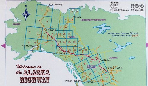
This booklet is the same size as all other ITMB atlases and is designed to fit comfortably in a user’s backpack, purse, or car door storage bin. The famous Alaska Highway of WW2 fame has been largely paved and straightened by now, but is still one of the paramount exploration adventures in the world and is far more accessible than the Karakoram or mid-Australia routes. The original highway, from Dawson Creek in northern British Columbia to close to Fairbanks, Alaska, has been supplemented by several off-shoots: the Dempster Highway leading to Inuvik, in Canada’s Northwest Territories, the Dalton Highway, leading north to the high Arctic at Prudhoe Bay in Alaska, and the Stewart Highway leading south through the Coastal Mountains to Prince Rupert, BC are all closely integrated with the traditional Alaska Highway. All of these are shown in great detail in this atlas. Road conditions, distances, campgrounds, convenient hiking trails, heights of land, parks, and everything else that we could think of to make this booklet useful has been included. It has also been very attractively priced, which I hope is being noted. This is a light-weight and nicely-presented attempt to move mapping forwards into its bright future as value-added information of use to users and affordably priced. In spite of the resemblance, the person shown on the cover is not Lan.
| Autor: | praca zbiorowa |
| Producent/Wydawnictwo: | ITMB |
| Rok wydania: | 2011 |
| Kod kreskowy: | 9781553419044 |
| Skala mapy / planu miasta: | 1:1 500 000 |
| Język: | angielski |
| Ilość stron: | 46 |
| Wymiary: | 21,5 x 15 cm |
| Okładka / oprawa: | miękka |
| Numer wydania: | 1 |
-
Promocja P

KRETA adventure atlas 1:50 000 ANAVASI 2019
KRETA adventure atlas 1:50 000 ANAVASI 2019119,00PLNStara cena 139,00Dodaj do koszykadodano produktprodukt niedostępny -
Nowość N Promocja PPolecany P

GLOBUS POLITYCZNY + ATLAS + APLIKACJA Demart 2024
GLOBUS POLITYCZNY + ATLAS + APLIKACJA Demart 202469,90PLNStara cena 79,90Dodaj do koszykadodano produktprodukt niedostępny -
Nowość N Promocja PPolecany P

ATLAS ŚWIATA DEMART 2022
ATLAS ŚWIATA DEMART 202254,90PLNStara cena 79,90Dodaj do koszykadodano produktprodukt niedostępny -
Nowość N Promocja PPolecany P

ELBE RIVER TRAIL 1 Praga - Magdeburg 1:75 000 atlas rowerowy BIKELINE 2022
ELBE RIVER TRAIL 1 Praga - Magdeburg 1:75 000 atlas rowerowy BIKELINE 202279,90PLNStara cena 89,90Dodaj do koszykadodano produktprodukt niedostępny -
Nowość N Promocja PPolecany P

ATLAS GEOGRAFICZNY dla liceum ogólnokształcącego i technikum NOWA ERA 2021
ATLAS GEOGRAFICZNY dla liceum ogólnokształcącego i technikum NOWA ERA 202156,90PLNStara cena 69,90Dodaj do koszykadodano produktprodukt niedostępny -
Promocja P

REKREACYJNE TRASY ROWEROWE OKOLICE WARSZAWY przewodnik COMPASS
REKREACYJNE TRASY ROWEROWE OKOLICE WARSZAWY przewodnik COMPASS9,90PLNStara cena 29,90Dodaj do koszykadodano produktprodukt niedostępny -
Nowość N Promocja PPolecany P

SZLAKI POLSKI wyd. DRAGON 2022
SZLAKI POLSKI wyd. DRAGON 202242,90PLNStara cena 69,95Dodaj do koszykadodano produktprodukt niedostępny -

ATLAS ŚWIATA podręczny EUROPILOT
18,60PLNDodaj do koszykadodano produktprodukt niedostępny -
Promocja P

MADRYT 3w1 przewodnik + atlas + mapa EXPRESSMAP
MADRYT 3w1 przewodnik + atlas + mapa EXPRESSMAP39,90PLNStara cena 69,90Dodaj do koszykadodano produktprodukt niedostępny -
Nowość N Promocja PPolecany P

ATLAS GEOGRAFICZNY Polska Kontynenty Świat NOWA ERA 2023
ATLAS GEOGRAFICZNY Polska Kontynenty Świat NOWA ERA 202369,90PLNStara cena 79,90Dodaj do koszykadodano produktprodukt niedostępny -
Promocja P

GRECJA ŚRODKOWA Central Greece road & touring atlas 1:50.000 ANAVASI
GRECJA ŚRODKOWA Central Greece road & touring atlas 1:50.000 ANAVASI109,90PLNStara cena 149,90Dodaj do koszykadodano produktprodukt niedostępny -
Nowość N Promocja PPolecany P

KARYNTIA mapa 1:150 000 FREYTAG & BERNDT 2022
KARYNTIA mapa 1:150 000 FREYTAG & BERNDT 202244,90PLNStara cena 54,90Dodaj do koszykadodano produktprodukt niedostępny -
Promocja PPolecany P

POLSKA KRAINY GEOGRAFICZNE PUZZLE PLUS ATLAS GEOGRAFICZNY DEMART
POLSKA KRAINY GEOGRAFICZNE PUZZLE PLUS ATLAS GEOGRAFICZNY DEMART34,90PLNStara cena 39,90Dodaj do koszykadodano produktprodukt niedostępny -
Promocja PPolecany P

The Times Universal Atlas of the World THE TIMES
The Times Universal Atlas of the World THE TIMES249,00PLNStara cena 309,00Dodaj do koszykadodano produktprodukt niedostępny -
Nowość N Promocja P

GEOGRAFIA. 28 kart edukacyjnych. Klasy 5-8 DEMART
GEOGRAFIA. 28 kart edukacyjnych. Klasy 5-8 DEMART19,90PLNStara cena 29,90Dodaj do koszykadodano produktprodukt niedostępny -
Promocja P

KANADA PÓŁNOCNO - ZACHODNIA ATLAS ITMB
KANADA PÓŁNOCNO - ZACHODNIA ATLAS ITMB59,90PLNStara cena 64,90Dodaj do koszykadodano produktprodukt niedostępny -
Promocja PPolecany P

MAZURY ZACHODNIE atlas turystyczny 1:50 000 CARTOMEDIA / EKO-KAPIO
MAZURY ZACHODNIE atlas turystyczny 1:50 000 CARTOMEDIA / EKO-KAPIO24,90PLNStara cena 49,90Dodaj do koszykadodano produktprodukt niedostępny -
Promocja PPolecany P

GEOGRAFIA ATLAS SZKOLNY Szkoła podstawowa, klasy 7-8 WSiP
GEOGRAFIA ATLAS SZKOLNY Szkoła podstawowa, klasy 7-8 WSiP42,90PLNStara cena 49,90Dodaj do koszykadodano produktprodukt niedostępny -

GEOGRAFICZNY ATLAS POLSKI DLA SZKÓŁ ŚREDNICH PPWK
29,90PLNDodaj do koszykadodano produktprodukt niedostępny -

ATLAS ŚWIATA EUROPILOT
24,90PLNDodaj do koszykadodano produktprodukt niedostępny -
Promocja PPolecany P

ELBE RIVER TRAIL 1 Praga - Magdeburg 1:75 000 atlas rowerowy BIKELINE 2019
ELBE RIVER TRAIL 1 Praga - Magdeburg 1:75 000 atlas rowerowy BIKELINE 201979,90PLNStara cena 89,90Dodaj do koszykadodano produktprodukt niedostępny -
Promocja PPolecany P

ŚWIAT MAJÓW - Ameryka Środkowa ATLAS SAMOCHODOWY ITMB
ŚWIAT MAJÓW - Ameryka Środkowa ATLAS SAMOCHODOWY ITMB64,90PLNStara cena 75,90Dodaj do koszykadodano produktprodukt niedostępny -
Promocja PPolecany P

MAJORKA atlas turystyczny plus mapa KOMPASS
MAJORKA atlas turystyczny plus mapa KOMPASS79,90PLNStara cena 89,90Dodaj do koszykadodano produktprodukt niedostępny -
Nowość N Promocja PPolecany P

WŁOCHY atlas samochodowy 1:200 000 TOURING EDITORE 2023/2024
WŁOCHY atlas samochodowy 1:200 000 TOURING EDITORE 2023/202499,90PLNStara cena 129,90Dodaj do koszykadodano produktprodukt niedostępny -
Promocja PPolecany P

KOLUMBIA BRYTYJSKA BRITISH COLUMBIA atlas ITMB
KOLUMBIA BRYTYJSKA BRITISH COLUMBIA atlas ITMB59,90PLNStara cena 69,90Dodaj do koszykadodano produktprodukt niedostępny -
Promocja PPolecany P

The Times Desktop Atlas of the World THE TIMES
The Times Desktop Atlas of the World THE TIMES99,90PLNStara cena 129,00Dodaj do koszykadodano produktprodukt niedostępny -
Nowość N Promocja PPolecany P

ATLAS BIBLIJNY w.3 BERNARDINUM 2023
ATLAS BIBLIJNY w.3 BERNARDINUM 2023179,90PLNStara cena 220,00Dodaj do koszykadodano produktprodukt niedostępny -

TATRY POLSKIE atlas kieszonkowy 1:30 000 SYGNATURA
8,99PLNDodaj do koszykadodano produktprodukt niedostępny -
Nowość N Promocja PPolecany P

The Times Reference Atlas of the World 2021
The Times Reference Atlas of the World 2021159,90PLNStara cena 199,90Dodaj do koszykadodano produktprodukt niedostępny -

GARDASEE atlas rowerowy BIKELINE
82,90PLNDodaj do koszykadodano produktprodukt niedostępny