
690990688
geograf.biuro@gmail.comSzanowni klienci, w trakcie zakupów prosimy o zwrócenie uwagi na czas realizacji zamówienia poszczególnego produktu, znajdujący sie pod ceną produktu.
Kategorie
Producenci

Dodano do przechowalni


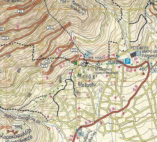
PARNITHA PARNIS mapa turystyczna 1:25 000 ANAVASI GRECJA

CENA: 34,90 PLN
Czas wysyłki : 24 Godziny
| Producent: ANAVASI |
| Kod EAN: |
")
Opis przedmiotu
PARNIS (MASYW) - PARNITHA
WODOODPORNA mapa turystyczna w skali 1:25 000
greckiego wydawnictwa
ANAVASI
Wydawnictwo ANAVASI powstało w Grecji w 1997 roku i dzisiaj oferuje ponad 100 różnych tytułów map w róznych skalach.
Dobrze znane greckie wydawnictwo kartograficzne ANAVASI specjalizuje sie w wysokiej jakości mapach turystycznych regionów, parków narodowych i wysp greckich.
Mapy tego wydawnictwa cechują sie bogactwem i rzetelnością informacji.
A new (5th) edition of Mt Parnitha map.
Mt Parnitha has a symbolic value for the residents of the capital. The fir forest, the ravines, the National Park, the deer, its numerous springs lay out wildlife a breath's distance away from the crowded city. This is why the 2007 forest fire had a profound psychological impact on the Athenians. However the biggest mistake after a disaster is to say, the mountain is destroyed I will never go there again. Mt Parnitha after the fire is like a patient: it needs more love and care than before. Fortunately there are many citizens who love Mt Parnitha. And instead of abandoning it they have intensified their activities on the mountain. New trails were opened, others have been maintained and in many cases waymarking has been improved. All these changes have been recorded on the new updated 5th edition of the map.
Specyfikacja
| Rok wydania: | 2011 |
| Kod kreskowy: | 9789608195554 |
| Skala mapy / planu miasta: | 1:25 000 |
| Język: | grecki angielski |
| Ilość stron: | 2 |
| Wymiary: | 24 x 12.5 cm |
| Okładka / oprawa: | twarda |
-
Promocja PPolecany P

EGINA AIGINA 10.00 mapa turystyczna 1:25 000 ANAVASI
EGINA AIGINA 10.00 mapa turystyczna 1:25 000 ANAVASI32,90PLNStara cena 36,90Dodaj do koszykadodano produktprodukt niedostępny -
Promocja PPolecany P

WYSPY SAROŃSKIE mapa 1:140 000 ORAMA
WYSPY SAROŃSKIE mapa 1:140 000 ORAMA44,90PLNStara cena 49,90Dodaj do koszykadodano produktprodukt niedostępny -

GERANIA mapa 1:25 000 ANAVASI
29,90PLNDodaj do koszykadodano produktprodukt niedostępny -

ŚRODKOWY HYMET mapa 1:10 000 ANAVASI
24,90PLNDodaj do koszykadodano produktprodukt niedostępny -
Nowość N Promocja PPolecany P

EGINA AIGINA 10.00 mapa 1:25 000 ANAVASI 2022
EGINA AIGINA 10.00 mapa 1:25 000 ANAVASI 202244,90PLNStara cena 49,90Dodaj do koszykadodano produktprodukt niedostępny -

GÓRA KITHAIRON mapa w skali 1:25 000 ANAVASI
32,90PLNDodaj do koszykadodano produktprodukt niedostępny -

SPETSES mapa turystyczna 1:12 500 ANAVASI GRECJA
24,90PLNDodaj do koszykadodano produktprodukt niedostępny -

SPETSES mapa samochodowa 1:25 000 ORAMA
27,90PLNDodaj do koszykadodano produktprodukt niedostępny -

HYDRA mapa samochodowa 1:30 000 ORAMA
27,90PLNDodaj do koszykadodano produktprodukt niedostępny -

EUBEA POŁUDNIOWA i WSCHODNIA ATTYKA mapa regionu 1:100 000 ANAVASI GRECJA
28,90PLNDodaj do koszykadodano produktprodukt niedostępny -

POROS mapa turystyczna 1:20 000 ORAMA
34,90PLNDodaj do koszykadodano produktprodukt niedostępny -
Nowość N Promocja PPolecany P

ATTYKA - VIOTIA mapa regionu 1:100 000 ANAVASI 2022
ATTYKA - VIOTIA mapa regionu 1:100 000 ANAVASI 202246,90PLNStara cena 52,90Dodaj do koszykadodano produktprodukt niedostępny -
Nowość N Promocja PPolecany P

ATENY I ATTYKA plan miasta 1:9 000 ANAVASI 2022
ATENY I ATTYKA plan miasta 1:9 000 ANAVASI 202222,90PLNStara cena 24,90Dodaj do koszykadodano produktprodukt niedostępny