
690990688
geograf.biuro@gmail.comSzanowni klienci, w trakcie zakupów prosimy o zwrócenie uwagi na czas realizacji zamówienia poszczególnego produktu, znajdujący sie pod ceną produktu.
Kategorie
Producenci


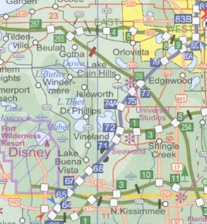
ORLANDO - CENTRALNA FLORYDA plan miasta 1:12 500 / 1:400 000 ITMB

| Producent: ITMB - International Travel Maps |
| Kod EAN: 9781553416791 |
")
Orlando and Central Florida
ORLANDO I ŚRODKOWA FLORYDA
plan miasta / mapa samochodowa w skali
1:12 500 / 1:400 000
kanadyjskiego wydawnictwa ITMB
ITMB Publishing (International Travel Maps and Books) producentem map i atlasów krajów i regionów całego świata. Specjalizującą się w Afryce, Azji, Kanadzie, Karaibach, Europie, Bliskim Wschodzie i Ameryce Łacińskiej.

ITMB’s Orlando and Central Florida combines a coast-to-coast road map of the central part of the state with four more detailed maps: Disney World, International Drive with the Sea World, a large plan of central Orlando, and a map of the wider region of the city including access to Disney World.
On one side is a road map at 1:400,000 of the central part of Florida covering the Space Coast and the Treasure Coast between Edgewater and Jupiter on the Atlantic side, and the Sun Coast plus the Nature Coast on the Gulf of Mexico, including Saint Petersburg, Tampa and Sarasota. Road network is neatly presented with road numbers on all roads and driving distance on federal and state highways. Toll plazas, services and rest areas are indicated and exits from main highways are clearly numbered.

The map also shows railway lines and local airports, plus indicates locations of numerous places of interest, including the area’s main attractions, with some places annotated with brief descriptions, national parks and state forest or other protected areas, Indian Reservations and military zones, etc. The map is indexed, but has no geographical coordinates.
Two thirds of the reverse side are taken up by a clear, indexed street plan of the central districts of Orlando at 1:12,500, extending from the theatres in the Orlando Loch Haven Park to Kaley Street on the south and from Sunset Lake in the west to the Orlando Festival Park. Hotels, places of worship, etc. are highlighted.
A wider region around the city is presented on a road map at 1:150,000 with main highways and connecting roads to the area’s numerous attractions. Also included is a plan of the Walt Disney World Resort at 1:44,000 and a map of the International Drive area including the Sea World, both annotated with hotels and sights.
| Producent/Wydawnictwo: | ITMB |
| Rok wydania: | 2008 |
| Kod kreskowy: | 9781553416791 |
| Skala mapy / planu miasta: | 1:12 500 / 1:400 000 |
| Język: | angielski |
| Ilość stron: | 2 |
| Wymiary: | 100 x 235 x 10 mm |
| Okładka / oprawa: | miękka |
-
Promocja PPolecany P

LOS ANGELES plan miasta laminowany 1:15 000 MARCO POLO
LOS ANGELES plan miasta laminowany 1:15 000 MARCO POLO19,90PLNStara cena 29,90Dodaj do koszykadodano produktprodukt niedostępny -

WASZYNGTON laminowany plan miasta 1:15 000 MARCO POLO
24,90PLNDodaj do koszykadodano produktprodukt niedostępny -
Promocja P

WASZYNGTON WASHINGTON DC mapa/ plan miasta PopOut Maps
WASZYNGTON WASHINGTON DC mapa/ plan miasta PopOut Maps14,99PLNStara cena 19,99Dodaj do koszykadodano produktprodukt niedostępny -
Polecany P

SAN FRANCISCO laminowany plan miasta 1:15 000 MARCO POLO
SAN FRANCISCO laminowany plan miasta 1:15 000 MARCO POLO29,90PLNDodaj do koszykadodano produktprodukt niedostępny -
Nowość N Promocja PPolecany P

WIELKI KANION I ARIZONA mapa ITMB 2022
WIELKI KANION I ARIZONA mapa ITMB 202254,90PLNStara cena 59,90Dodaj do koszykadodano produktprodukt niedostępny -
Promocja P

PHILADELPHIA plan miasta laminowany 1:7 000 BORCH MAP
PHILADELPHIA plan miasta laminowany 1:7 000 BORCH MAP22,90PLNStara cena 39,90Dodaj do koszykadodano produktprodukt niedostępny -
Promocja P

CHICAGO plan miasta laminowany 1:8 000 BORCH MAP
CHICAGO plan miasta laminowany 1:8 000 BORCH MAP19,90PLNStara cena 39,90Dodaj do koszykadodano produktprodukt niedostępny -
Promocja PPolecany P

CHICAGO plan miasta laminowany 1:15 000 MARCO POLO
CHICAGO plan miasta laminowany 1:15 000 MARCO POLO19,90PLNStara cena 29,90Dodaj do koszykadodano produktprodukt niedostępny -

LAS VEGAS mapa/ plan miasta PopOut Map
19,99PLNDodaj do koszykadodano produktprodukt niedostępny -

CHICAGO mapa/ plan miasta PopOut Maps
19,99PLNDodaj do koszykadodano produktprodukt niedostępny -
Promocja P

MIAMI mapa/ plan miasta PopOut Maps
MIAMI mapa/ plan miasta PopOut Maps14,99PLNStara cena 19,99Dodaj do koszykadodano produktprodukt niedostępny -
Promocja PPolecany P

MANHATTAN 1:12 500 STAN NOWY JORK 1:1 000 000 mapa ITMB
MANHATTAN 1:12 500 STAN NOWY JORK 1:1 000 000 mapa ITMB54,90PLNStara cena 59,90Dodaj do koszykadodano produktprodukt niedostępny -

LAS VEGAS - NEVADA plan miasta UNIVERSALMAP
26,90PLNDodaj do koszykadodano produktprodukt niedostępny -
Promocja PPolecany P

MIAMI I PD FLORYDA plan miasta 1:12 500 / 1:400 000 ITMB - International Travel Maps
MIAMI I PD FLORYDA plan miasta 1:12 500 / 1:400 000 ITMB - International Travel Maps46,90PLNStara cena 59,90Dodaj do koszykadodano produktprodukt niedostępny -

MANHATTAN plan miasta laminowany 1:15 000 wyd. BORCH
24,90PLNDodaj do koszykadodano produktprodukt niedostępny -
Promocja PPolecany P

TEXAS I OKLAHOMA mapa wodoodporna ITMB
TEXAS I OKLAHOMA mapa wodoodporna ITMB49,90PLNStara cena 59,90Dodaj do koszykadodano produktprodukt niedostępny -
Promocja PPolecany P

PHILADELPHIA mapa / plan miasta PopOut Maps
PHILADELPHIA mapa / plan miasta PopOut Maps16,99PLNStara cena 19,99Dodaj do koszykadodano produktprodukt niedostępny -
Promocja PPolecany P

SAN FRANCISCO plan miasta 1:12 500 PÓŁNOCNA KALIFORNIA mapa ITMB
SAN FRANCISCO plan miasta 1:12 500 PÓŁNOCNA KALIFORNIA mapa ITMB44,90PLNStara cena 59,90Dodaj do koszykadodano produktprodukt niedostępny -

PHOENIX plan miasta laminowany 1:20 000 / 1:105 000 BORCH
24,90PLNDodaj do koszykadodano produktprodukt niedostępny -
Nowość N Promocja PPolecany P

HONOLULU I OAHU mapa wodoodporna ITMB 2022
HONOLULU I OAHU mapa wodoodporna ITMB 202254,90PLNStara cena 59,90Dodaj do koszykadodano produktprodukt niedostępny -

BOSTON plan miasta laminowany 1:15 000 MARCO POLO
21,90PLNDodaj do koszykadodano produktprodukt niedostępny -

SEATTLE - WASHINGTON plan miasta UNIVERSALMAP USA
24,90PLNDodaj do koszykadodano produktprodukt niedostępny -
Promocja P

CHICAGO mapa laminowana 1:9 000 BERNDTSONMAP
CHICAGO mapa laminowana 1:9 000 BERNDTSONMAP34,90PLNStara cena 44,90Dodaj do koszykadodano produktprodukt niedostępny -
Nowość N Promocja PPolecany P

NOWY ORLEAN / RZEKA MISSISSIPPI mapa ITMB 2022
NOWY ORLEAN / RZEKA MISSISSIPPI mapa ITMB 202254,90PLNStara cena 59,90Dodaj do koszykadodano produktprodukt niedostępny -
 plan miasta UNIVERSALMAP")
INDIANAPOLIS (INDIANA) plan miasta UNIVERSALMAP
25,90PLNDodaj do koszykadodano produktprodukt niedostępny -
Promocja P

WASZYNGTON plan miasta 1:12 000 MICHELIN
WASZYNGTON plan miasta 1:12 000 MICHELIN26,90PLNStara cena 39,90Dodaj do koszykadodano produktprodukt niedostępny -

SEATTLE plan miasta laminowany 1:10 000 wyd. BORCH MAPS
29,90PLNDodaj do koszykadodano produktprodukt niedostępny -

NOWY ORLEAN mapa/ plan miasta PopOut Maps
NOWY ORLEAN mapa/ plan miasta PopOut Maps19,99PLNDodaj do koszykadodano produktprodukt niedostępny -

BOSTON mapa/ plan miasta PopOut Maps
19,99PLNDodaj do koszykadodano produktprodukt niedostępny -
Promocja PPolecany P

NEW YORK CITY / NOWY JORK plan miasta laminowany 1:15 000 BORCH 2020
NEW YORK CITY / NOWY JORK plan miasta laminowany 1:15 000 BORCH 202039,90PLNStara cena 44,90Dodaj do koszykadodano produktprodukt niedostępny