
690990688
geograf.biuro@gmail.comSzanowni klienci, w trakcie zakupów prosimy o zwrócenie uwagi na czas realizacji zamówienia poszczególnego produktu, znajdujący sie pod ceną produktu.
Kategorie
Producenci


Trekking the West Highland Way KEO 2021

| Producent: Knife Edge Outdoor |
| Kod EAN: 9781912933112 |
")
")
")
")
")
")
")
")
")
")
")
")
")
")
Trekking the West Highland Way
Knife Edge Outdoor 2021
Real Maps: Full Ordnance Survey Explorer mapping inside (1:25,000)
17 different itineraries: schedules of 3, 4, 5, 6, 7, 8, 9, 10 and 11 days for hikers and runners. Includes both southbound and northbound itineraries. Difficult calculations of time, distance and altitude gain are done for you.
Also includes:
- Detailed information on equipment and travelling light
- Everything the trekker needs to know: route, costs, difficulty, weather, travel, and more
- Full accommodation listings: the best inns, B&Bs and hotels
- Detailed section on camping
- Essential info for both self-guided and guided trekkers
- Information on geology, history, plants and wildlife
- Numbered waypoints linking the Real Maps to our clear descriptions
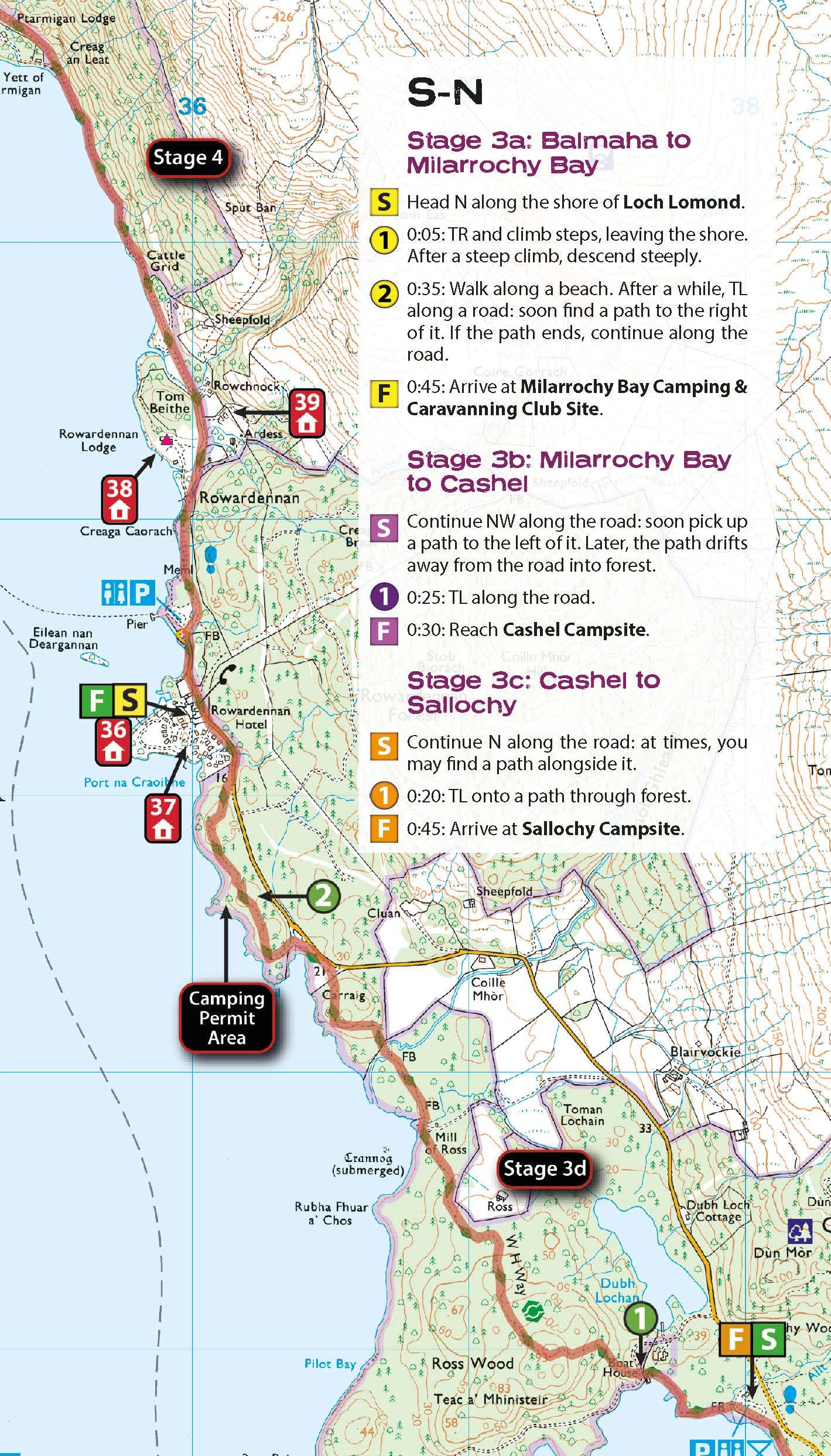
The West Highland Way, which is one of ‘Scotland’s Great Trails’, travels 96 miles through sublime scenery, from the outskirts of Glasgow to Fort William. In between, there are countless magnificent mountains, exquisite glens, shimmering lochs and seemingly endless miles of purple heather to experience. The trekker negotiates this wonderfully unpopulated terrain on a meticulously waymarked series of paths and tracks, many of which are old military roads or drovers’ paths, built many centuries ago. In this part of the Highlands, you are far away from the region’s urban centres. Occasionally, you will meet a road or pass through a small village or hamlet (with little more than a local pub and a few places to stay) but otherwise, the experience is one of tranquillity. This is the Scottish Highlands at their best and it will be an adventure that you will never forget.
| Autor: | Andrew McCluggage |
| Producent/Wydawnictwo: | Knife Edge Outdoor / Ordnance Survey |
| Rok wydania: | 2021 |
| Kod kreskowy: | 9781912933112 |
| Skala mapy / planu miasta: | 1:25 000 (mapy wydanictwa IGN) |
| Język: | angielski |
| Ilość stron: | 156 |
| Wymiary: | 12,1 x 21 cm |
| Okładka / oprawa: | miękka |
| Numer wydania: | 1 |
-
Nowość N Promocja PPolecany P

Epic Road Trips of Europe 1 LONELY PLANET 2022
Epic Road Trips of Europe 1 LONELY PLANET 2022159,90PLNStara cena 169,90Dodaj do koszykadodano produktprodukt niedostępny -
Nowość N Promocja PPolecany P

WEST HIGHLAND WAY mapa / atlas 1:25 000 CICERONE 2023
WEST HIGHLAND WAY mapa / atlas 1:25 000 CICERONE 202356,90PLNStara cena 64,90Dodaj do koszykadodano produktprodukt niedostępny -

LONDYN ilustrowany przewodnik PASCAL
36,90PLNDodaj do koszykadodano produktprodukt niedostępny -

LONDYN Udany Weekend przewodnik MICHELIN
20,90PLNDodaj do koszykadodano produktprodukt niedostępny -
Nowość N Promocja PPolecany P

TORONTO 2 przewodnik POCKET LONELY PLANET 2022
TORONTO 2 przewodnik POCKET LONELY PLANET 202248,90PLNStara cena 59,90Dodaj do koszykadodano produktprodukt niedostępny -

GÓRY KALEDOŃSKIE przewodnik turystyczny FOCUS FOOTPRINT
36,00PLNDodaj do koszykadodano produktprodukt niedostępny -
Promocja PPolecany P

WEST HIGHLAND WAY przewodnik turystyczny CICERONE 2021
WEST HIGHLAND WAY przewodnik turystyczny CICERONE 202189,90PLNStara cena 99,90Dodaj do koszykadodano produktprodukt niedostępny -
Nowość N Promocja P

DUBLIN I IRLANDIA Pascal Lajt przewodnik PASCAL 2019
DUBLIN I IRLANDIA Pascal Lajt przewodnik PASCAL 201923,90PLNStara cena 26,90Dodaj do koszykadodano produktprodukt niedostępny -
Promocja PPolecany P

CRUISE GUIDE TO EUROPE & THE MEDITERRANEAN przewodnik DK
CRUISE GUIDE TO EUROPE & THE MEDITERRANEAN przewodnik DK39,90PLNStara cena 99,90Dodaj do koszykadodano produktprodukt niedostępny -
Promocja PPolecany P

LONDYN 12 przewodnik + plan miasta LONELY PLANET 2022
LONDYN 12 przewodnik + plan miasta LONELY PLANET 202259,90PLNStara cena 109,90Dodaj do koszykadodano produktprodukt niedostępny -

DUBLIN - MIASTA MARZEŃ przewodnik turystyczny AGORA
26,90PLNDodaj do koszykadodano produktprodukt niedostępny -
Nowość N Promocja PPolecany P

LONDYN przewodnik turystyczny DK 2021
LONDYN przewodnik turystyczny DK 202184,90PLNStara cena 99,90Dodaj do koszykadodano produktprodukt niedostępny -
Promocja PPolecany P

IRLANDIA 15 przewodnik LONELY PLANET 2022
IRLANDIA 14 przewodnik LONELY PLANET 202059,90PLNStara cena 129,90Dodaj do koszykadodano produktprodukt niedostępny -
Promocja PPolecany P

LONDYN przewodnik TRAVELBOOK BEZDROŻA 2019
LONDYN przewodnik TRAVELBOOK BEZDROŻA 201922,90PLNStara cena 26,90Dodaj do koszykadodano produktprodukt niedostępny -
Nowość N Promocja PPolecany P

EUROVELO 1 przewodnik rowerowy BIKELINE 2022
EUROVELO 1 przewodnik rowerowy BIKELINE 202299,90PLNStara cena 109,90Dodaj do koszykadodano produktprodukt niedostępny -
Promocja PPolecany P

WIELKA BRYTANIA POZNAWAJ ŚWIAT Dawid Lasociński HORYZONTY
WIELKA BRYTANIA POZNAWAJ ŚWIAT Dawid Lasociński HORYZONTY34,90PLNStara cena 38,90Dodaj do koszykadodano produktprodukt niedostępny -
Promocja P

KORNWALIA przewodnik turystyczny COLLINS
KORNWALIA przewodnik turystyczny COLLINS44,90PLNStara cena 49,90Dodaj do koszykadodano produktprodukt niedostępny -
Nowość N Promocja PPolecany P

LONDYN Pocket 8 przewodnik LONELY PLANET 2023
LONDYN Pocket 8 przewodnik LONELY PLANET 202354,90PLNStara cena 69,90Dodaj do koszykadodano produktprodukt niedostępny -
Nowość N Promocja PPolecany P

IRLANDIA IRELAND 13 przewodnik ROUGH GUIDES 2021
IRLANDIA IRELAND 13 przewodnik ROUGH GUIDES 202189,90PLNStara cena 99,90Dodaj do koszykadodano produktprodukt niedostępny -
Promocja P

LONDYN przewodnik TRAVELBOOK BEZDROŻA
LONDYN przewodnik TRAVELBOOK BEZDROŻA13,99PLNStara cena 24,90Dodaj do koszykadodano produktprodukt niedostępny -

DUBLIN przewodnik INSIGHT SMART GUIDE
19,90PLNDodaj do koszykadodano produktprodukt niedostępny -

IRLANDIA IRELAND przewodnik ROUGH GUIDES 2011
74,95PLNDodaj do koszykadodano produktprodukt niedostępny -

GUERNSEY przewodnik GREAT BREAKS INSIGHT 2017
44,90PLNDodaj do koszykadodano produktprodukt niedostępny -

IRLANDIA BACK ROADS przewodnik DK 25 Wycieczki
69,90PLNDodaj do koszykadodano produktprodukt niedostępny -
Promocja PPolecany P

HEBRYDY The Hebridean Way przewodnik CICERONE
HEBRYDY The Hebridean Way przewodnik CICERONE84,90PLNStara cena 94,90Dodaj do koszykadodano produktprodukt niedostępny -

YORKSHIRE przewodnik ROUGH GUIDES
64,95PLNDodaj do koszykadodano produktprodukt niedostępny -
Nowość N Promocja PPolecany P

SZKOCJA 12 przewodnik LONELY PLANET 2023
SZKOCJA 12 przewodnik LONELY PLANET 202379,90PLNStara cena 109,90Dodaj do koszykadodano produktprodukt niedostępny -
Nowość N Promocja P

Cornwall & The Isles of Scilly przewodnik BRADT 2019
Cornwall & The Isles of Scilly przewodnik BRADT 201959,90PLNStara cena 89,90Dodaj do koszykadodano produktprodukt niedostępny -
Promocja PPolecany P

HEBRYDY ZEWNĘTRZNE Outer Hebrides przewodnik BRADT 2020
HEBRYDY ZEWNĘTRZNE Outer Hebrides przewodnik BRADT 202094,90PLNStara cena 109,90Dodaj do koszykadodano produktprodukt niedostępny -
Nowość N Promocja P

HEBRYDY WEWNĘTRZNE Inner Hebrides przewodnik BRADT 2020
HEBRYDY WEWNĘTRZNE Inner Hebrides przewodnik BRADT 202089,00PLNStara cena 99,00Dodaj do koszykadodano produktprodukt niedostępny