
690990688
geograf.biuro@gmail.comSzanowni klienci, w trakcie zakupów prosimy o zwrócenie uwagi na czas realizacji zamówienia poszczególnego produktu, znajdujący sie pod ceną produktu.
Kategorie
Producenci


YOSEMITE NE 308 TUOLUMNE MEADOWS mapa wodoodporna 1:40 000 NATIONAL GEOGRAPHIC

| Producent: NATIONAL GEOGRAPHIC |
| Kod EAN: 9781566953696 |
")
")
")
")
")
")
YOSEMITE National Park
NE: Tuolumne Meadows and Hoover Wilderness
Składana mapa wodoodporna
NATIONAL GEOGRAPHIC
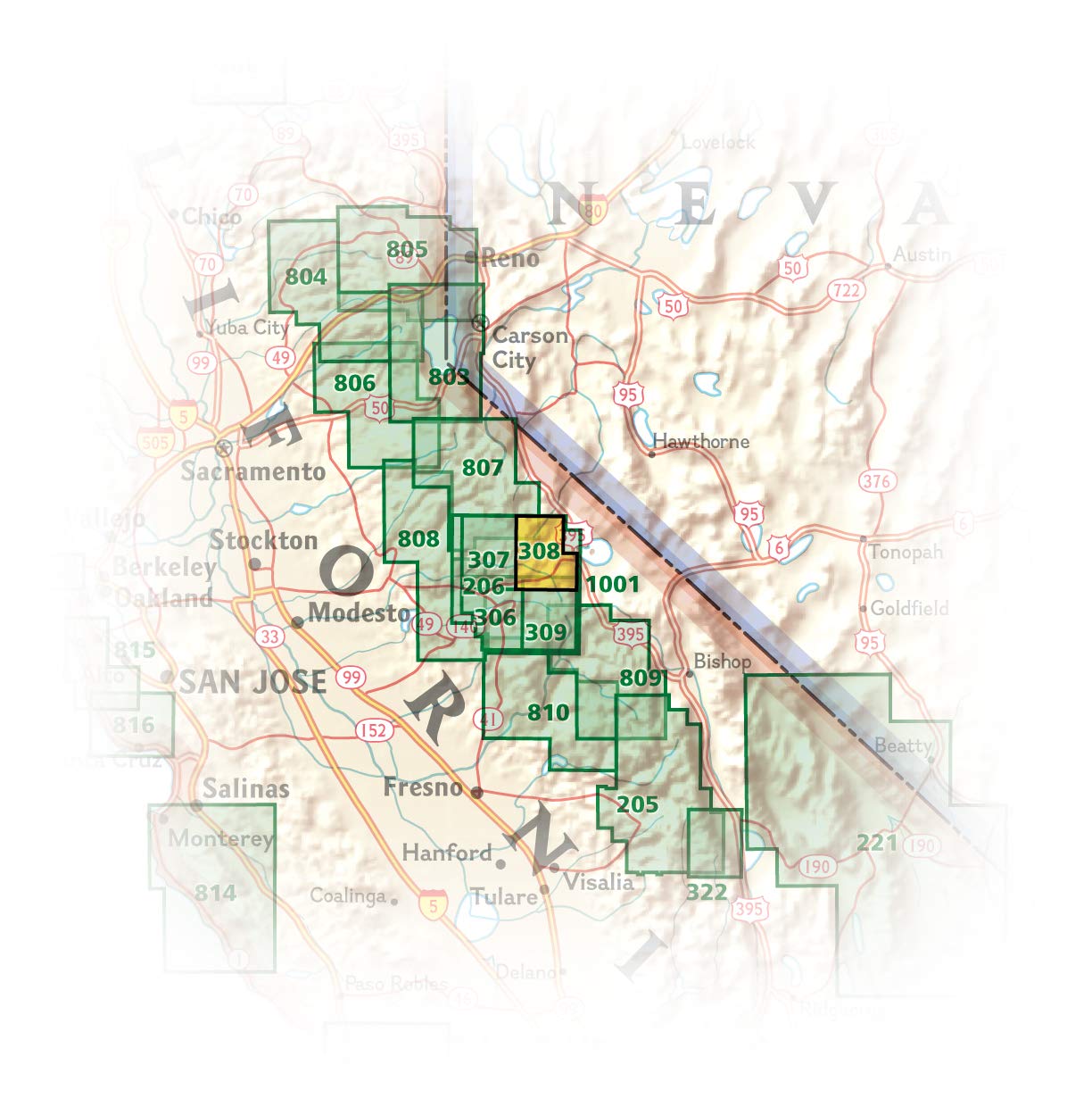
National Geographic's Trails Illustrated map of Yosemite NE: Tuolumne Meadows and Hoover Wilderness is designed to meet the needs of outdoor enthusiasts by combining valuable information with unmatched detail of this magnificent region of the park. Expertly researched and created in partnership with local land management agencies, this map features key points of interest including Twin Lakes, Tuolumne River, Grand Canyon of the Tuolumne, and portions of Ansel Adams Wilderness, Mono Basin National Forest Scenic Area, and Yosemite Wilderness.
With miles of mapped trails including portions of the Pacific Crest and John Muir trails, this map can guide you off the beaten path and back again in some of the most breathtaking scenery in the Sierras. Trail mileage between intersections will help you choose the path that's right for you. Camping, hiking, wilderness permit, and safety information is included to help guide you in enjoying all the park has to offer. The map base includes contour lines and elevations for summits, passes, and many lakes. Recreation features are clearly marked, including campgrounds, picnic areas, trailheads, horse stables, ski areas, and more.
Every Trails Illustrated map is printed on "Backcountry Tough" waterproof, tear-resistant paper. A full UTM grid is printed on the map to aid with GPS navigation.
Other features found on this map include: Ansel Adams Wilderness, Excelsior Mountain, Hoover Wilderness, Inyo National Forest, Matterhorn Peak, Mount Dana, Tioga Pass, Toiyabe National Forest, Yosemite National Park.

| Autor: | praca zbiorowa |
| Producent/Wydawnictwo: | National Geographic |
| Rok wydania: | 2019 |
| Kod kreskowy: | 9781566953696 |
| Skala mapy / planu miasta: | 1:40 000 |
| Język: | angielski |
| Wymiary: | 19 x 10 cm |
| Okładka / oprawa: | miękka wodoodporna |
| Numer części w serii: | 308 |
-
Promocja P

MIAMI mapa/ plan miasta PopOut Maps
MIAMI mapa/ plan miasta PopOut Maps14,99PLNStara cena 19,99Dodaj do koszykadodano produktprodukt niedostępny -
Promocja PPolecany P

MANHATTAN 1:12 500 STAN NOWY JORK 1:1 000 000 mapa ITMB
MANHATTAN 1:12 500 STAN NOWY JORK 1:1 000 000 mapa ITMB54,90PLNStara cena 59,90Dodaj do koszykadodano produktprodukt niedostępny -
Promocja P

ACADIA turystyczna mapa wodoodporna 212 NATIONAL GEOGRAPHIC
ACADIA turystyczna mapa wodoodporna 212 NATIONAL GEOGRAPHIC54,90PLNStara cena 64,90Dodaj do koszykadodano produktprodukt niedostępny -
Promocja PPolecany P

POLSKA mapa wodoodporna 3330 NATIONAL GEOGRAPHIC 2019
POLSKA mapa wodoodporna 3330 NATIONAL GEOGRAPHIC 201954,90PLNStara cena 69,90Dodaj do koszykadodano produktprodukt niedostępny -
Nowość N Promocja PPolecany P

USA KANADA MEKSYK atlas NATIONAL GEOGRAPHIC 2023
USA KANADA MEKSYK atlas NATIONAL GEOGRAPHIC 202359,90PLNStara cena 79,90Dodaj do koszykadodano produktprodukt niedostępny -
Promocja PPolecany P

AMERYKA PÓŁNOCNA składana mapa polityczna 1:8 000 000 FREYTAG & BERNDT
AMERYKA PÓŁNOCNA składana mapa polityczna 1:8 000 000 FREYTAG & BERNDT59,90PLNStara cena 79,90Dodaj do koszykadodano produktprodukt niedostępny -
Nowość N Promocja PPolecany P

NOWY JORK MANHATTAN BROOKLYN QUEENS XL 2w1 przewodnik i mapa EXPRESSMAP 2023
NOWY JORK MANHATTAN BROOKLYN QUEENS XL 2w1 przewodnik i mapa EXPRESSMAP 202329,90PLNStara cena 36,90Dodaj do koszykadodano produktprodukt niedostępny -
Promocja PPolecany P

SEATTLE I STAN WASHINGTON mapa ITMB 2020
SEATTLE I STAN WASHINGTON mapa ITMB 202054,90PLNStara cena 59,90Dodaj do koszykadodano produktprodukt niedostępny -
Promocja PPolecany P

USA POŁUDNIOWA KANADA mapa 1:3 000 000 FREYTAG & BERNDT
USA POŁUDNIOWA KANADA mapa 1:3 000 000 FREYTAG & BERNDT44,90PLNStara cena 59,90Dodaj do koszykadodano produktprodukt niedostępny -
Nowość N Promocja PPolecany P

NOWY JORK plan miasta laminowany EXPRESSMAP 2023
NOWY JORK plan miasta laminowany EXPRESSMAP 202329,90PLNStara cena 39,90Dodaj do koszykadodano produktprodukt niedostępny -
Promocja PPolecany P
 mapa wodoodporna 1:35 000 NATIONAL GEOGRAPHIC 2022")
ARCHES NP (Utah) mapa wodoodporna 1:35 000 NATIONAL GEOGRAPHIC 2022
ARCHES NP (Utah) mapa wodoodporna 1:35 000 NATIONAL GEOGRAPHIC 202269,90PLNStara cena 79,90Dodaj do koszykadodano produktprodukt niedostępny -
Nowość N Promocja PPolecany P

ŚWIAT POLITYCZNY I FIZYCZNY mapa 1:20 000 000 FREYTAG & BERNDT 2023
ŚWIAT POLITYCZNY I FIZYCZNY mapa 1:20 000 000 FREYTAG & BERNDT 202354,90PLNStara cena 59,90Dodaj do koszykadodano produktprodukt niedostępny -
Nowość N Promocja PPolecany P

AMERYKA PÓŁNOCNA ŚRODKOWA KARAIBY mapa wodoodporna NATIONAL GEOGRAPHIC 2022
AMERYKA PÓŁNOCNA ŚRODKOWA KARAIBY mapa wodoodporna NATIONAL GEOGRAPHIC 202269,90PLNStara cena 79,90Dodaj do koszykadodano produktprodukt niedostępny -
Nowość N Promocja PPolecany P

USA mapa laminowana samochodowo-turystyczna 1:4 750 000 EXPRESSMAP 2024
USA mapa laminowana samochodowo-turystyczna 1:4 750 000 EXPRESSMAP 202426,90PLNStara cena 36,90Dodaj do koszykadodano produktprodukt niedostępny -
Nowość N Promocja PPolecany P

USA KANADA MEKSYK atlas samochodowy NATIONAL GEOGRAPHIC 2024
USA KANADA MEKSYK atlas samochodowy NATIONAL GEOGRAPHIC 2024129,90PLNStara cena 149,90Dodaj do koszykadodano produktprodukt niedostępny -
Nowość N Promocja PPolecany P

HAWAJE I HONOLULU mapa wodoodporna 1:150 000/ 1:35 000 ITMB 2023
HAWAJE I HONOLULU mapa wodoodporna 1:150 000/ 1:35 000 ITMB 202354,90PLNStara cena 59,90Dodaj do koszykadodano produktprodukt niedostępny -

CHICAGO plan miasta laminowany 1:12 000 KUNTH
21,99PLNDodaj do koszykadodano produktprodukt niedostępny -

USA WIELKIE JEZIORA GREAT LAKES mapa 1:1 000 000 ITMB
34,90PLNDodaj do koszykadodano produktprodukt niedostępny -

TENNESSEE mapa samochodowa 1:1 000 000 National Geographic
32,90PLNDodaj do koszykadodano produktprodukt niedostępny -
Promocja PPolecany P

ZION NP turystyczna mapa wodoodporna 1:37 700 NATIONAL GEOGRAPHIC 2019
ZION NP turystyczna mapa wodoodporna 1:37 700 NATIONAL GEOGRAPHIC 201979,90PLNStara cena 89,90Dodaj do koszykadodano produktprodukt niedostępny -

BAJA KALIFORNIA PŁ mapa wodoodporna NATIONAL GEOGRAPHIC
49,90PLNDodaj do koszykadodano produktprodukt niedostępny -
Promocja P

WIELKIE JEZIORA Great Lakes mapa samochodowa 172 MICHELIN
WIELKIE JEZIORA Great Lakes mapa samochodowa 172 MICHELIN29,90PLNStara cena 44,90Dodaj do koszykadodano produktprodukt niedostępny