
690990688
geograf.biuro@gmail.comSzanowni klienci, w trakcie zakupów prosimy o zwrócenie uwagi na czas realizacji zamówienia poszczególnego produktu, znajdujący sie pod ceną produktu.
Kategorie
Producenci


KOPENHAGA plan miasta laminowany 1:12 500 INSIGHT

| Producent: INSIGHT |
| Kod EAN: |
")
KOPENHAGA
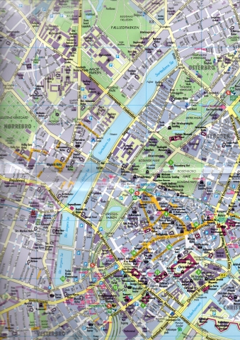
plan miasta laminowanany
1:12 500
mapa zawiera:
- plan miasta w sklai 1:12 500
- Plan/mapa całego miasta i ościennych w skali 1:115 000
- mapę Wschodniej Danii i Południowo zachodniej Szwecji w skali 1:4 000 000
- spis ulic
- informacje turystyczne
- opis zabytków i miejsc atrakcyjnych turystycznie
- mapa metra
- mapa regionu w skali 1:300 000
mapa w języku angielskim
MAPA LAMINOWANA
Doskonała i niezawodna mapa laminowana brytyjskiego wydawnictwa Insight oferującego ponad 500 tytułów map i przewodników całego świata.
Mapy Insight Flexi Map to papier wodoodporny po którym bez problemu można pisac ścieralnymi pisakami. Zawierają liczne plany i mapy przedstawiamego regionu. Szczgółowa kartografia i wspaniale opisane atrakcje turystyczne czynią te mapy doskonałym towarzyszem podróży gwarantując niezapomniane wrażenia.
Mapa jest bardzo poręczna i bez problemu składa się nie zajmując zbyt wiele miejsca.
Flexi Map Copenhagen is a laminated, tear-resistant map which has 3 maps, each accompanied by its own index.
It includes a list - with descriptions and some photographs - of 23 recommended sights, divided by theme and linked to the mapping by numbered markers. There is also a handy information section with concise details on getting around, tourist offices, money, tipping, opening times, public holidays, telecommunications, emergency telephone numbers and climate.
On the main map, shown at a scale ...of 1:12,500 (1cm = 0.125km), streets are named and a selection of hotels, public buildings and key sights are prominently marked, pedestrian areas and one-way systems are also shown. The comprehensive index is divided into categories for ease of use. A detailed Metro plan is located on the back cover for easy reference.
A Copenhagen area map can be found on the reverse and shows the various routes into the city by road and rail. Also included is a map of the wider area, shown at a scale of 1:300,000 (1cm =3km). In addition to the road and rail networks, it provides a picture of the region's topography through the use of relief shading. Intermediate distance indicators are given on the main routes.
| Rok wydania: | 2013 |
| Kod kreskowy: | 9781780056005 |
| Skala mapy / planu miasta: | 1:12 500 |
| Język: | angielski |
| Ilość stron: | 2 |
| Wymiary: | 10 x 22 cm |
| Okładka / oprawa: | miękka laminowana |
-
Promocja PPolecany P

BORNHOLM mapa turystyczna 1:45 000 STUDIO PLAN
BORNHOLM mapa turystyczna 1:45 000 STUDIO PLAN11,90PLNStara cena 16,90Dodaj do koszykadodano produktprodukt niedostępny -
Nowość N Promocja PPolecany P

EUROPA mapa laminowana 1:4 000 000 EXPRESSMAP 2023
EUROPA mapa laminowana 1:4 000 000 EXPRESSMAP 202326,90PLNStara cena 36,90Dodaj do koszykadodano produktprodukt niedostępny -
Nowość N Promocja PPolecany P

DANIA PÓŁNOCNA I POŁUDNIOWA KOMPLET 2 MAPY ROWEROWE + INFORMATOR 1:150 000 FREYTAG & BERNDT
DANIA PÓŁNOCNA I POŁUDNIOWA KOMPLET 2 MAPY ROWEROWE + INFORMATOR 1:150 000 FREYTAG & BERNDT76,90PLNStara cena 99,90Dodaj do koszykadodano produktprodukt niedostępny -
Promocja PPolecany P

BORNHOLM + CHRISTIANSO mapa turystyczna EKOMAP
BORNHOLM + CHRISTIANSO mapa turystyczna EKOMAP9,90PLNStara cena 16,90Dodaj do koszykadodano produktprodukt niedostępny -
Nowość N Promocja PPolecany P

BORNHOLM wodoodporna mapa rowerowa 1:50 000 Nordisk Korthandel 2022
BORNHOLM wodoodporna mapa rowerowa 1:50 000 Nordisk Korthandel 202279,90PLNStara cena 89,90Dodaj do koszykadodano produktprodukt niedostępny -
Promocja P

KOPENHAGA COPENHAGEN mapa/ plan miasta PopOut Maps
KOPENHAGA COPENHAGEN mapa/ plan miasta PopOut Maps12,99PLNStara cena 19,99Dodaj do koszykadodano produktprodukt niedostępny -
Promocja PPolecany P

KOPENHAGA plan miasta laminowany 1:11 000 BORCH 2023
KOPENHAGA plan miasta laminowany 1:11 000 BORCH 202344,90PLNStara cena 49,90Dodaj do koszykadodano produktprodukt niedostępny -
Promocja PPolecany P

JEZIORO BODEŃSKIE mapa rowerowa 1:150 000 ADFC 2020
JEZIORO BODEŃSKIE mapa rowerowa 1:150 000 ADFC 202054,90PLNStara cena 59,90Dodaj do koszykadodano produktprodukt niedostępny -
Promocja PPolecany P

GRENLANDIA mapa 1:1 900 000 REISE KNOW HOW 2019
GRENLANDIA mapa 1:1 900 000 REISE KNOW HOW 201944,90PLNStara cena 54,90Dodaj do koszykadodano produktprodukt niedostępny -
Nowość N Promocja PPolecany P

EUROPA mapa 1:3 000 000 MICHELIN 2023
EUROPA mapa 1:3 000 000 MICHELIN 202324,90PLNStara cena 49,90Dodaj do koszykadodano produktprodukt niedostępny -
Nowość N Promocja PPolecany P

DANIA GRENLANDIA WYSPY OWCZE mapa 1:400 000 FREYTAG & BERNDT 2022
DANIA GRENLANDIA WYSPY OWCZE mapa 1:400 000 FREYTAG & BERNDT 202244,90PLNStara cena 59,90Dodaj do koszykadodano produktprodukt niedostępny -

KRAJE BAŁTYCKIE laminowana mapa samochodowa 1:800 000 KUNTH
29,90PLNDodaj do koszykadodano produktprodukt niedostępny -

DANIA GRENLANDIA WYSPY OWCZE mapa samochodowa 1:400 000 FREYTAG & BERNDT
24,90PLNDodaj do koszykadodano produktprodukt niedostępny -
Promocja PPolecany P

EUROPA SZLAKI PIELGRZYMKOWE mapa 1:3 500 000 1:2 000 000 FREYTAG & BERNDT
EUROPA SZLAKI PIELGRZYMKOWE mapa 1:3 500 000 1:2 000 000 FREYTAG & BERNDT49,90PLNStara cena 59,90Dodaj do koszykadodano produktprodukt niedostępny -

POMIĘDZY MORZAMI BAŁTYCKIM I PÓŁNOCNYM mapa 1:150 000 FREYTAG & BERNDT
24,90PLNDodaj do koszykadodano produktprodukt niedostępny -
Nowość N Promocja PPolecany P

EUROPA DROGI KOLEJOWE mapa 1:5 000 000 Kummerly + Frey 2024
EUROPA DROGI KOLEJOWE mapa 1:5 000 000 Kummerly + Frey 202454,90PLNStara cena 59,90Dodaj do koszykadodano produktprodukt niedostępny -
Nowość N Promocja PPolecany P

DANIA JUTLANDIA PÓŁNOC mapa rowerowa ADFC 2023
DANIA JUTLANDIA PÓŁNOC mapa rowerowa ADFC 202354,90PLNStara cena 59,90Dodaj do koszykadodano produktprodukt niedostępny -
Promocja PPolecany P

KOPENHAGA plan miasta laminowany 1:15 000 MARCO POLO
KOPENHAGA plan miasta laminowany 1:15 000 MARCO POLO19,90PLNStara cena 29,90Dodaj do koszykadodano produktprodukt niedostępny -
Nowość N Promocja PPolecany P

EUROPA mapa drogowa 1:3 000 000 MICHELIN 2024
EUROPA mapa drogowa 1:3 000 000 MICHELIN 202444,90PLNStara cena 49,90Dodaj do koszykadodano produktprodukt niedostępny -
Nowość N Promocja PPolecany P

SKANDYNAWIA atlas samochodowy 1:200 000 - 1:400 000 FREYTAG&BERNDT 2024
SKANDYNAWIA atlas samochodowy 1:200 000 - 1:400 000 FREYTAG&BERNDT 2024149,90PLNStara cena 179,90Dodaj do koszykadodano produktprodukt niedostępny -
Promocja PPolecany P

KOPENHAGA plan miasta laminowany 1:11 000 BORCH
KOPENHAGA plan miasta laminowany 1:11 000 BORCH29,90PLNStara cena 39,90Dodaj do koszykadodano produktprodukt niedostępny -
Nowość N Promocja PPolecany P

EUROPA PÓŁNOCNA SKANDYNAWIA mapa 1:2 000 000 FREYTAG & BERNDT 2023
EUROPA PÓŁNOCNA SKANDYNAWIA mapa 1:2 000 000 FREYTAG & BERNDT 202346,90PLNStara cena 59,90Dodaj do koszykadodano produktprodukt niedostępny -

DANIA - JUTLANDIA PÓŁNOCNA- ARHUS - AALBORG mapa samochodowa 1:190 000 Kummerly + Frey
50,90PLNDodaj do koszykadodano produktprodukt niedostępny -

DANIA - KOPENHAGA - BORNHOLM mapa samochodowa 1:190 000 Kummerly + Frey
50,90PLNDodaj do koszykadodano produktprodukt niedostępny -
Nowość N Promocja PPolecany P

GRENLANDIA I BIEGUN PÓŁNOCNY mapa 1:3 000 000 / 1:9 000 000 ITMB 2023
GRENLANDIA I BIEGUN PÓŁNOCNY mapa 1:3 000 000 / 1:9 000 000 ITMB 202354,90PLNStara cena 59,90Dodaj do koszykadodano produktprodukt niedostępny -
Nowość N Promocja PPolecany P

EUROPA WSCHODNIA mapa drogowa / kolejowa ITMB 2021
EUROPA WSCHODNIA mapa drogowa / kolejowa ITMB 202142,90PLNStara cena 49,90Dodaj do koszykadodano produktprodukt niedostępny -
Promocja PPolecany P

BORNHOLM WK236 mapa turystyczna 1:50 000 KOMPASS 2020
BORNHOLM WK236 mapa turystyczna 1:50 000 KOMPASS 202054,90PLNStara cena 59,90Dodaj do koszykadodano produktprodukt niedostępny -
Nowość N Promocja PPolecany P

DANIA mapa samochodowa 1:330 000 MICHELIN 2022
DANIA mapa samochodowa 1:330 000 MICHELIN 202249,90PLNStara cena 54,90Dodaj do koszykadodano produktprodukt niedostępny -
Nowość N Promocja PPolecany P

KOPENHAGA 3w1 plan miasta 1:14 000 HALLWAG 2021
KOPENHAGA 3w1 plan miasta 1:14 000 HALLWAG 202139,90PLNStara cena 44,90Dodaj do koszykadodano produktprodukt niedostępny -
Nowość N Promocja P

WSCHODNIA JUTLANDIA mapa rowerowa 1:100 000 SCANMAPS 2019
WSCHODNIA JUTLANDIA mapa rowerowa 1:100 000 SCANMAPS 201964,90PLNStara cena 72,90Dodaj do koszykadodano produktprodukt niedostępny