
690990688
geograf.biuro@gmail.comSzanowni klienci, w trakcie zakupów prosimy o zwrócenie uwagi na czas realizacji zamówienia poszczególnego produktu, znajdujący sie pod ceną produktu.
Kategorie
Producenci


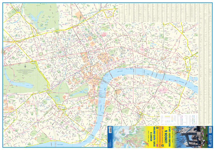
LONDYN - ANGLIA POŁUDNIOWA / WALIA mapa wodoodporna 1:8 000/ 1:600 000 ITMB

| Producent: ITMB - International Travel Maps |
| Kod EAN: 9781553415213 |
")
")
")
")
London & England South / Wales
wodoodporna mapa samochodowa w skali 1:8 000 / 1:300 000
kanadyjskiego wydawnictwa ITMB Publishing

London is one of the most fascinating cities in the world and yet is one that is very difficult to map. The surface roads are often short, and the longer roads change names every few blocks. The underground system is a nightmare to map accurately and the overground is difficult, simply because only some overground rail lines are used by London Transport. The rest are used for freight or for inter-city travel and are operated by the railways. Regardless, the purpose of a travel map of London is to show the many museums, theatres, attractions, and parks that make London such a unique entity, and this our map does, including incorporating just a few of the hundreds of pubs on to our map. Exciting though London is, most people visiting it want to explore beyond the limits of a city map, so we have used the back side to portray all of southern England south of the Wash and all of Wales on to the map. This map shows all the towns within easy striking distance of London - Canterbury, Oxford, Norwich, Birmingham, Chester, and Lincoln - all the motorways, A roads, B roads and even the smaller local roads, although at 1:600,000 scale, such roads add little to the map. Naturally, ITMB has added castles, famous gardens, some National Trust properties (including Newton's birthplace!), with an inset map of the Channel Islands. Information is incredibly dense on this map.
| Autor: | praca zbiorowa |
| Producent/Wydawnictwo: | ITMB |
| Rok wydania: | 2014 |
| Kod kreskowy: | 9781553415213 |
| Skala mapy / planu miasta: | 1:8 000 / 1:600 000 |
| Język: | angielski |
| Ilość stron: | 2 |
| Wymiary: | 10,5 x 25 cm |
| Okładka / oprawa: | miękka wodoodporna |
| Numer wydania: | 3 |
-
Promocja PPolecany P

MALAGA plan miasta 1:10 000 MICHELIN
MALAGA plan miasta 1:10 000 MICHELIN42,90PLNStara cena 44,90Dodaj do koszykadodano produktprodukt niedostępny -
Promocja PPolecany P

EDYNBURG EDINBURGH plan miasta LONELY PLANET
EDYNBURG EDINBURGH mapa/ plan miasta PopOut Maps34,90PLNStara cena 39,90Dodaj do koszykadodano produktprodukt niedostępny -
Promocja P

BRISTOL mapa/ plan miasta PopOut Maps
BRISTOL mapa/ plan miasta PopOut Maps16,99PLNStara cena 19,99Dodaj do koszykadodano produktprodukt niedostępny -
Promocja PPolecany P

SZKOCJA ZACHODNIA I HEBRYDY mapa 1:250 000 Ordnance Survey
SZKOCJA ZACHODNIA I HEBRYDY mapa 1:250 000 Ordnance Survey44,90PLNStara cena 49,90Dodaj do koszykadodano produktprodukt niedostępny -
Promocja PPolecany P

WYSPA ŚWIĘTEJ HELENY mapa geograficzna 1:35 000 GIZIMAP
WYSPA ŚWIĘTEJ HELENY mapa geograficzna 1:35 000 GIZIMAP49,90PLNStara cena 59,90Dodaj do koszykadodano produktprodukt niedostępny -
Promocja PPolecany P

EDYNBURG mapa kieszonkowa 1:11 000 COLLINS 2020
EDYNBURG mapa kieszonkowa 1:11 000 COLLINS 202026,90PLNStara cena 29,90Dodaj do koszykadodano produktprodukt niedostępny -
Promocja PPolecany P

SZKOCJA SZETLANDY ORKANY mapa 1:250 000 ORDNANCE SURVEY 2020
SZKOCJA SZETLANDY ORKANY mapa 1:250 000 ORDNANCE SURVEY 202044,90PLNStara cena 49,90Dodaj do koszykadodano produktprodukt niedostępny -
Promocja PPolecany P

SZKOCJA PÓŁNOC I WYSPY mapa 1:300 000 ITMB 2020
SZKOCJA PÓŁNOC I WYSPY mapa 1:300 000 ITMB 202049,90PLNStara cena 59,90Dodaj do koszykadodano produktprodukt niedostępny -
Promocja PPolecany P

KORNWALIA mapa turystyczna 1:100 000 ORDNANCE SURVEY
KORNWALIA mapa turystyczna 1:100 000 ORDNANCE SURVEY44,90PLNStara cena 49,90Dodaj do koszykadodano produktprodukt niedostępny -

CAMBRIDGE mapa/ plan miasta PopOut Maps
16,99PLNDodaj do koszykadodano produktprodukt niedostępny -
.jpg "BATH mapa/ plan miasta PopOut Maps")
BATH mapa/ plan miasta PopOut Maps
BATH mapa/ plan miasta PopOut Maps16,99PLNDodaj do koszykadodano produktprodukt niedostępny -

OXFORD mapa/ plan miasta PopOut Maps
19,99PLNDodaj do koszykadodano produktprodukt niedostępny -
Promocja PPolecany P

SZKOCJA ŚRODKOWA I POŁUDNIOWA mapa 1:300 000 ITMB
SZKOCJA ŚRODKOWA I POŁUDNIOWA mapa 1:300 000 ITMB54,90PLNStara cena 59,90Dodaj do koszykadodano produktprodukt niedostępny -
Nowość N Promocja PPolecany P

SZKOCJA 6 mapa 1:400 000 REISE KNOW HOW 2023
SZKOCJA 6 mapa 1:400 000 REISE KNOW HOW 202352,90PLNStara cena 59,90Dodaj do koszykadodano produktprodukt niedostępny -

ANGLIA POŁUDNIOWA I WALIA mapa samochodowa 1:300 000 MARCO POLO
22,90PLNDodaj do koszykadodano produktprodukt niedostępny -
Nowość N Promocja PPolecany P

EUROPA mapa 1:3 000 000 MICHELIN 2023
EUROPA mapa 1:3 000 000 MICHELIN 202324,90PLNStara cena 49,90Dodaj do koszykadodano produktprodukt niedostępny -
Promocja P

FALKLANDY mapa 1:365 000 Ocean Explorer Map
FALKLANDY mapa 1:365 000 Ocean Explorer Map69,90PLNStara cena 89,90Dodaj do koszykadodano produktprodukt niedostępny -
Promocja PPolecany P

KORNWALIA CORNWALL mapa 1:150 000 FREYTAG & BERNDT
KORNWALIA CORNWALL mapa 1:150 000 FREYTAG & BERNDT49,90PLNStara cena 59,90Dodaj do koszykadodano produktprodukt niedostępny -
Nowość N

WIELKA BRYTANIA I IRLANDIA atlas samochodowy MICHELIN 2016
84,90PLNDodaj do koszykadodano produktprodukt niedostępny -
Nowość N Promocja PPolecany P

Cape Wrath Trail North XT40 mapa wodoodporna 1:40 000 HARVEY 2022
Cape Wrath Trail North XT40 mapa wodoodporna 1:40 000 HARVEY 202299,90PLNStara cena 124,90Dodaj do koszykadodano produktprodukt niedostępny -
Nowość N Promocja PPolecany P

Cape Wrath Trail South XT40 mapa wodoodporna 1:40 000 HARVEY 2022
Cape Wrath Trail South XT40 mapa wodoodporna 1:40 000 HARVEY 202299,90PLNStara cena 124,90Dodaj do koszykadodano produktprodukt niedostępny -
Promocja PPolecany P

EUROPA SZLAKI PIELGRZYMKOWE mapa 1:3 500 000 1:2 000 000 FREYTAG & BERNDT
EUROPA SZLAKI PIELGRZYMKOWE mapa 1:3 500 000 1:2 000 000 FREYTAG & BERNDT49,90PLNStara cena 59,90Dodaj do koszykadodano produktprodukt niedostępny -

IRLANDIA mapa samochodowa 1:300 000 MARCO POLO
23,90PLNDodaj do koszykadodano produktprodukt niedostępny -

LONDYN mapa/ plan miasta PopOut Map
19,99PLNDodaj do koszykadodano produktprodukt niedostępny -
Nowość N Promocja PPolecany P

SKYE TRAIL mapa wodoodporna 1:40 000 HARVEY 2023
SKYE TRAIL mapa wodoodporna 1:40 000 HARVEY 202396,90PLNStara cena 169,90Dodaj do koszykadodano produktprodukt niedostępny -
Promocja P

BELFAST plan miasta 1:12 000 Ordnance Survey
BELFAST plan miasta 1:12 000 Ordnance Survey49,90PLNStara cena 59,90Dodaj do koszykadodano produktprodukt niedostępny -
Nowość N Promocja PPolecany P

EUROPA DROGI KOLEJOWE mapa 1:5 000 000 Kummerly + Frey 2024
EUROPA DROGI KOLEJOWE mapa 1:5 000 000 Kummerly + Frey 202454,90PLNStara cena 59,90Dodaj do koszykadodano produktprodukt niedostępny -
Promocja P

YORK mapa/ plan miasta PopOut Maps
YORK mapa/ plan miasta PopOut Maps13,99PLNStara cena 19,99Dodaj do koszykadodano produktprodukt niedostępny -
Promocja P

LONDYN plan miasta laminowany 1:11 000 BORCH
LONDYN plan miasta laminowany 1:11 000 BORCH19,90PLNStara cena 39,90Dodaj do koszykadodano produktprodukt niedostępny -
Promocja P

WEST HIGHLAND WAY mapa wodoodporna 1:40 000 HARVEY
WEST HIGHLAND WAY mapa wodoodporna 1:40 000 HARVEY99,90PLNStara cena 119,90Dodaj do koszykadodano produktprodukt niedostępny