
690990688
geograf.biuro@gmail.comSzanowni klienci, w trakcie zakupów prosimy o zwrócenie uwagi na czas realizacji zamówienia poszczególnego produktu, znajdujący sie pod ceną produktu.
Kategorie
Producenci


CORK - IRLANDIA mapa turystyczna wodoodoporna XPLOREIT MAPS

| Producent: Xploreit Map IRLANDIA |
| Kod EAN: 9780955265525 |
")
Turystyczno samochodowa mapa wodoodporna irlandzkiego wydawnictwa kartograficznego Xploreit Maps
CORK
w skali 1:100 000
Podział map na arkusze:
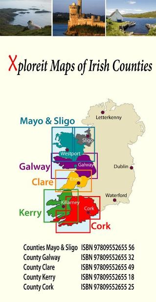
The Xploreit Map of County Cork includes all of Cork along with parts of counties Kerry, Limerick, Tipperary and Waterford. Cork's rich heritage of megalithic monuments, medieval churches and castles can instantly be identified. Noted sites such as Blarney Castle, St. Finbarr's Oratory at Gougane Barra and McCarthy's Bar in Castletownbere are featured in red text. Whether you want to explore Youghal's town walls in the east, savour the views from the footbridge at Mizen Head in the south-west or or imagine times past as you stroll around Mitchelstown's King's Square and Kingston College in the north it's easy to find your chosen destination. Showing a large array of golf courses, angling spots, sandy beaches for swimming and surfing, equestrian facilities, boating facilities, this map is an indispensable tool for visitors. Several scenic drives, cycle routes and waymarked walks are shown. The scale of the Cork map is 1:100,000.

Walking Routes
All the National Waymarked routes and an extensive selection of looped walks in Cork are shown. Some are listed below:
- The Blackwater Way
- The Ballyhoura Way
- The Beara Way
- The Sheep's Head Way
- The Seven Heads Walk
- Doctors Hill Loop
- Mullaghareirk Loop
- The Seven Heads Walk
Cycling Routes
All the main cycling routes are shown:
- The Gougane Barra Cycle Route
- The Blackwater Cycle Route
- The Duhallow Cycle Route
- The Beara Cycle Route
- The Sheep's Head Cycle Route
- The Youghal Cycle Route
| Autor: | praca zbiorowa |
| Producent/Wydawnictwo: | XPLOREIT MAPS |
| Rok wydania: | 2008 |
| Kod kreskowy: | 9780955265525 |
| Skala mapy / planu miasta: | 1:100 000 |
| Język: | angielski |
-
Promocja PPolecany P

MALAGA plan miasta 1:10 000 MICHELIN
MALAGA plan miasta 1:10 000 MICHELIN42,90PLNStara cena 44,90Dodaj do koszykadodano produktprodukt niedostępny -
Promocja PPolecany P

EDYNBURG EDINBURGH plan miasta LONELY PLANET
EDYNBURG EDINBURGH mapa/ plan miasta PopOut Maps34,90PLNStara cena 39,90Dodaj do koszykadodano produktprodukt niedostępny -
Promocja P

BRISTOL mapa/ plan miasta PopOut Maps
BRISTOL mapa/ plan miasta PopOut Maps16,99PLNStara cena 19,99Dodaj do koszykadodano produktprodukt niedostępny -
Promocja PPolecany P

SZKOCJA ZACHODNIA I HEBRYDY mapa 1:250 000 Ordnance Survey
SZKOCJA ZACHODNIA I HEBRYDY mapa 1:250 000 Ordnance Survey44,90PLNStara cena 49,90Dodaj do koszykadodano produktprodukt niedostępny -
Promocja PPolecany P

WYSPA ŚWIĘTEJ HELENY mapa geograficzna 1:35 000 GIZIMAP
WYSPA ŚWIĘTEJ HELENY mapa geograficzna 1:35 000 GIZIMAP49,90PLNStara cena 59,90Dodaj do koszykadodano produktprodukt niedostępny -
Promocja PPolecany P

EDYNBURG mapa kieszonkowa 1:11 000 COLLINS 2020
EDYNBURG mapa kieszonkowa 1:11 000 COLLINS 202026,90PLNStara cena 29,90Dodaj do koszykadodano produktprodukt niedostępny -
Promocja PPolecany P

SZKOCJA SZETLANDY ORKANY mapa 1:250 000 ORDNANCE SURVEY 2020
SZKOCJA SZETLANDY ORKANY mapa 1:250 000 ORDNANCE SURVEY 202044,90PLNStara cena 49,90Dodaj do koszykadodano produktprodukt niedostępny -
Promocja PPolecany P

SZKOCJA PÓŁNOC I WYSPY mapa 1:300 000 ITMB 2020
SZKOCJA PÓŁNOC I WYSPY mapa 1:300 000 ITMB 202049,90PLNStara cena 59,90Dodaj do koszykadodano produktprodukt niedostępny -
Promocja PPolecany P

KORNWALIA mapa turystyczna 1:100 000 ORDNANCE SURVEY
KORNWALIA mapa turystyczna 1:100 000 ORDNANCE SURVEY44,90PLNStara cena 49,90Dodaj do koszykadodano produktprodukt niedostępny -

CAMBRIDGE mapa/ plan miasta PopOut Maps
16,99PLNDodaj do koszykadodano produktprodukt niedostępny -

OXFORD mapa/ plan miasta PopOut Maps
19,99PLNDodaj do koszykadodano produktprodukt niedostępny -
Promocja PPolecany P

SZKOCJA ŚRODKOWA I POŁUDNIOWA mapa 1:300 000 ITMB
SZKOCJA ŚRODKOWA I POŁUDNIOWA mapa 1:300 000 ITMB54,90PLNStara cena 59,90Dodaj do koszykadodano produktprodukt niedostępny -

ANGLIA POŁUDNIOWA I WALIA mapa samochodowa 1:300 000 MARCO POLO
22,90PLNDodaj do koszykadodano produktprodukt niedostępny -
.jpg "BATH mapa/ plan miasta PopOut Maps")
BATH mapa/ plan miasta PopOut Maps
BATH mapa/ plan miasta PopOut Maps16,99PLNDodaj do koszykadodano produktprodukt niedostępny -
Nowość N Promocja PPolecany P

EUROPA mapa 1:3 000 000 MICHELIN 2023
EUROPA mapa 1:3 000 000 MICHELIN 202324,90PLNStara cena 49,90Dodaj do koszykadodano produktprodukt niedostępny -
Promocja P

FALKLANDY mapa 1:365 000 Ocean Explorer Map
FALKLANDY mapa 1:365 000 Ocean Explorer Map69,90PLNStara cena 89,90Dodaj do koszykadodano produktprodukt niedostępny -
Nowość N Promocja PPolecany P

SZKOCJA 6 mapa 1:400 000 REISE KNOW HOW 2023
SZKOCJA 6 mapa 1:400 000 REISE KNOW HOW 202352,90PLNStara cena 59,90Dodaj do koszykadodano produktprodukt niedostępny -
Promocja PPolecany P

KORNWALIA CORNWALL mapa 1:150 000 FREYTAG & BERNDT
KORNWALIA CORNWALL mapa 1:150 000 FREYTAG & BERNDT49,90PLNStara cena 59,90Dodaj do koszykadodano produktprodukt niedostępny -
Nowość N

WIELKA BRYTANIA I IRLANDIA atlas samochodowy MICHELIN 2016
84,90PLNDodaj do koszykadodano produktprodukt niedostępny -
Nowość N Promocja PPolecany P

Cape Wrath Trail North XT40 mapa wodoodporna 1:40 000 HARVEY 2022
Cape Wrath Trail North XT40 mapa wodoodporna 1:40 000 HARVEY 202299,90PLNStara cena 124,90Dodaj do koszykadodano produktprodukt niedostępny -
Nowość N Promocja PPolecany P

Cape Wrath Trail South XT40 mapa wodoodporna 1:40 000 HARVEY 2022
Cape Wrath Trail South XT40 mapa wodoodporna 1:40 000 HARVEY 202299,90PLNStara cena 124,90Dodaj do koszykadodano produktprodukt niedostępny -
Promocja PPolecany P

EUROPA SZLAKI PIELGRZYMKOWE mapa 1:3 500 000 1:2 000 000 FREYTAG & BERNDT
EUROPA SZLAKI PIELGRZYMKOWE mapa 1:3 500 000 1:2 000 000 FREYTAG & BERNDT49,90PLNStara cena 59,90Dodaj do koszykadodano produktprodukt niedostępny -

IRLANDIA mapa samochodowa 1:300 000 MARCO POLO
23,90PLNDodaj do koszykadodano produktprodukt niedostępny -

LONDYN mapa/ plan miasta PopOut Map
19,99PLNDodaj do koszykadodano produktprodukt niedostępny -
Nowość N Promocja PPolecany P

SKYE TRAIL mapa wodoodporna 1:40 000 HARVEY 2023
SKYE TRAIL mapa wodoodporna 1:40 000 HARVEY 202396,90PLNStara cena 169,90Dodaj do koszykadodano produktprodukt niedostępny -
Promocja P

BELFAST plan miasta 1:12 000 Ordnance Survey
BELFAST plan miasta 1:12 000 Ordnance Survey49,90PLNStara cena 59,90Dodaj do koszykadodano produktprodukt niedostępny -
Promocja PPolecany P

WALIA I PD-ZACH ANGLIA 1:300 000 mapa ITMB
WALIA I PD-ZACH ANGLIA 1:300 000 mapa ITMB49,90PLNStara cena 59,90Dodaj do koszykadodano produktprodukt niedostępny -
Promocja PPolecany P

EDYNBURG I SZKOCJA POŁUDNIOWA mapa 1:10 000 / 370 000 ITMB
EDYNBURG I SZKOCJA POŁUDNIOWA mapa 1:10 000 / 370 000 ITMB54,90PLNStara cena 59,90Dodaj do koszykadodano produktprodukt niedostępny -

DUBLIN mapa/ plan miasta PopOut Map
19,99PLNDodaj do koszykadodano produktprodukt niedostępny -
Promocja PPolecany P

ANGLIA POŁUDNIOWO - ZACHODNIA mapa 1:250 000 Ordnance Survey 2020
ANGLIA POŁUDNIOWO - ZACHODNIA mapa 1:250 000 Ordnance Survey 202044,90PLNStara cena 49,90Dodaj do koszykadodano produktprodukt niedostępny