
690990688
geograf.biuro@gmail.comSzanowni klienci, w trakcie zakupów prosimy o zwrócenie uwagi na czas realizacji zamówienia poszczególnego produktu, znajdujący sie pod ceną produktu.
Kategorie
Producenci


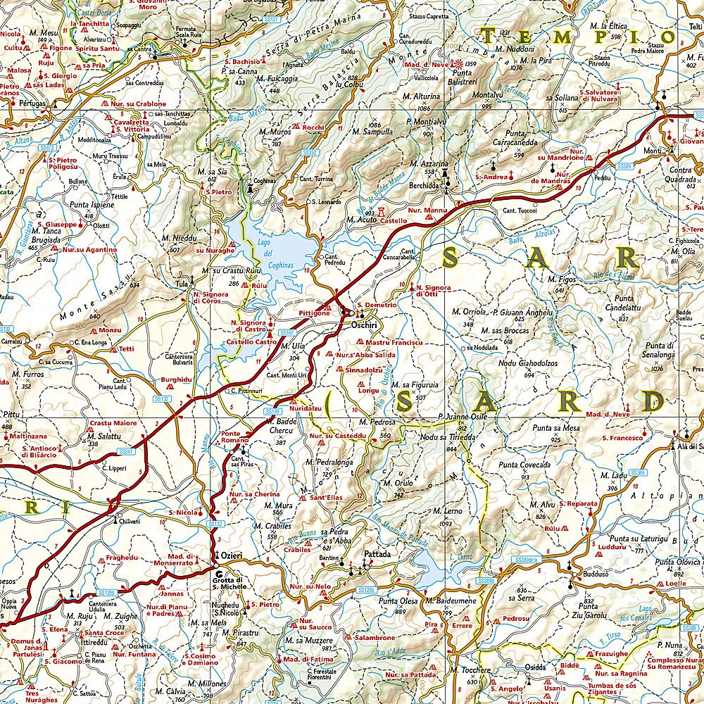
SARDYNIA mapa wodoodporna NATIONAL GEOGRAPHIC 2022

| Producent: NATIONAL GEOGRAPHIC |
| Kod EAN: 9781566955416 |
")
")
")
")
")
SARDYNIA
Składana mapa wodoodporna wydana przez
NATIONAL GEOGRAPHIC 2022
National Geographic's Sardinia Adventure Map provides global travelers with the perfect combination of detail and perspective in a highly functional travel tool. Cities and towns are easy to find with the map's helpful index. Expressways, major routes, and other roads are clearly designated and include distance in kilometers so travelers can easily plan their best route. Hundreds of points of interest and diverse and unique destinations are highlighted including beaches, caves, campsites, monuments, churches, castles, and more.

Sardinia's northern half is shown on the front side of the print map including the cities of Sassari, Castelsardo, Olbia, La Maddalena, and Nuoro. The reverse side of the map covers the southern portion of the region and shows the cities of Cagliari, Oristano, Iglesia, Sant' Antioco, and Tortoli.
Sardinia is the second largest island in the Mediterranean Sea. Unlike its sister island Sicily, Sardinia boasts extensive mountain ranges, wide valleys, and broad plateaus. The island is one of the most geologically ancient bodies of land in Europe and unlike Italy and Sicily it is not earthquake-prone. Although Sardinia is surrounded by the clear waters of the Mediterranean, the island itself is relatively dry and has only one natural lake. However, several man-made lakes have been constructed, including Lake Omodeo which was constructed in the 1920's and was for many years the largest reservoir in Europe.
Every Adventure Map is printed on durable synthetic paper, making them waterproof, tear-resistant and tough — capable of withstanding the rigors of international travel.


| Autor: | praca zbiorowa |
| Producent/Wydawnictwo: | National Geographic |
| Rok wydania: | 2022 |
| Kod kreskowy: | 9781566955416 |
| Skala mapy / planu miasta: | 1:220 000 |
| Język: | angielski |
| Ilość stron: | 2 |
| Wymiary: | 11 x 23 cm |
| Okładka / oprawa: | miękka wodoodporna |
| Numer części w serii: | 3309 |
-
Nowość N Promocja PPolecany P

EUROPA ŚRODKOWA mapa samochodowa 1:2 000 000 FREYTAG&BRENDT 2022
EUROPA ŚRODKOWA mapa samochodowa 1:2 000 000 FREYTAG&BRENDT 202249,90PLNStara cena 59,90Dodaj do koszykadodano produktprodukt niedostępny -
Nowość N Promocja PPolecany P

EUROPA mapa laminowana 1:4 000 000 EXPRESSMAP 2023
EUROPA mapa laminowana 1:4 000 000 EXPRESSMAP 202326,90PLNStara cena 36,90Dodaj do koszykadodano produktprodukt niedostępny -
Nowość N Promocja PPolecany P

WENECJA 2w1 przewodnik i mapa EXPRESSMAP 2023
WENECJA 2w1 przewodnik i mapa EXPRESSMAP 202326,90PLNStara cena 29,90Dodaj do koszykadodano produktprodukt niedostępny -
Promocja PPolecany P

JEZIORO COMO laminowana mapa trekkingowa 1:50 000 EXPRESSMAP
JEZIORO COMO laminowana mapa trekkingowa 1:50 000 EXPRESSMAP44,90PLNStara cena 59,90Dodaj do koszykadodano produktprodukt niedostępny -
Promocja PPolecany P

Alto Garda / Ledro / Monte Baldo North 061 mapa turystyczna 1:25 000 TABACCO 2021
Alto Garda / Ledro / Monte Baldo North 061 mapa turystyczna 1:25 000 TABACCO 202146,90PLNStara cena 54,90Dodaj do koszykadodano produktprodukt niedostępny -
Nowość N Promocja PPolecany P

TOSKANIA FLORENCJA SIENA PIZA 2w1 przewodnik i mapa EXPRESSMAP 2023
TOSKANIA FLORENCJA SIENA PIZA 2w1 przewodnik i mapa EXPRESSMAP 202326,90PLNStara cena 34,90Dodaj do koszykadodano produktprodukt niedostępny -
Nowość N Promocja P

SYCYLIA mapa samochodowa 1:200 000 TOURING EDITORE 2020
SYCYLIA mapa samochodowa 1:200 000 TOURING EDITORE 202036,90PLNStara cena 44,90Dodaj do koszykadodano produktprodukt niedostępny -
Nowość N Promocja PPolecany P

EUROPA mapa 1:3 000 000 MICHELIN 2023
EUROPA mapa 1:3 000 000 MICHELIN 202324,90PLNStara cena 49,90Dodaj do koszykadodano produktprodukt niedostępny -
Nowość N Promocja PPolecany P

MEDIOLAN plan miasta 1:15 000 TOURING EDITORE 2022
MEDIOLAN plan miasta 1:15 000 TOURING EDITORE 202244,90PLNStara cena 49,90Dodaj do koszykadodano produktprodukt niedostępny -
Promocja PPolecany P

EUROPA SZLAKI PIELGRZYMKOWE mapa 1:3 500 000 1:2 000 000 FREYTAG & BERNDT
EUROPA SZLAKI PIELGRZYMKOWE mapa 1:3 500 000 1:2 000 000 FREYTAG & BERNDT49,90PLNStara cena 59,90Dodaj do koszykadodano produktprodukt niedostępny -

JEZIORA GÓRNYCH WŁOCH mapa dla motocyklistów HALLWAG
69,90PLNDodaj do koszykadodano produktprodukt niedostępny -

SARDYNIA mapa dla motocyklistów HALLWAG
69,90PLNDodaj do koszykadodano produktprodukt niedostępny -
Promocja PPolecany P

MEDIOLAN plan miasta 1:15 000 TOURING EDITORE
MEDIOLAN plan miasta 1:15 000 TOURING EDITORE24,90PLNStara cena 44,90Dodaj do koszykadodano produktprodukt niedostępny -
Nowość N Promocja PPolecany P

SARDYNIA PÓŁNOCNA mapa turystyczna 1:50 000 KOMPASS 2023
SARDYNIA PÓŁNOCNA mapa turystyczna 1:50 000 KOMPASS 202382,90PLNStara cena 109,90Dodaj do koszykadodano produktprodukt niedostępny -
Nowość N Promocja PPolecany P

EUROPA DROGI KOLEJOWE mapa 1:5 000 000 Kummerly + Frey 2024
EUROPA DROGI KOLEJOWE mapa 1:5 000 000 Kummerly + Frey 202454,90PLNStara cena 59,90Dodaj do koszykadodano produktprodukt niedostępny -
Nowość N Promocja PPolecany P

SYCYLIA dwie mapy rowerowe + informator FREYTAG & BERNDT 2023
SYCYLIA dwie mapy rowerowe + informator FREYTAG & BERNDT 202389,90PLNStara cena 99,90Dodaj do koszykadodano produktprodukt niedostępny -
Promocja PPolecany P

WŁOCHY PÓŁNOCNE mapa 1:400 000 REISE KNOW HOW 2020
WŁOCHY PÓŁNOCNE mapa 1:400 000 REISE KNOW HOW 202044,90PLNStara cena 49,90Dodaj do koszykadodano produktprodukt niedostępny -
Nowość N Promocja PPolecany P

EUROPA mapa drogowa 1:3 000 000 MICHELIN 2024
EUROPA mapa drogowa 1:3 000 000 MICHELIN 202444,90PLNStara cena 49,90Dodaj do koszykadodano produktprodukt niedostępny -

SARDYNIA POŁUDNIOWA mapa turystyczna 1:50 000 KOMPASS 2016
84,90PLNDodaj do koszykadodano produktprodukt niedostępny -
Nowość N Promocja P

072 LIENZER DOLOMITEN LESACHTAL OBERTILLIACH mapa turystyczna 1:25 000 TABACCO
072 LIENZER DOLOMITEN LESACHTAL OBERTILLIACH mapa turystyczna 1:25 000 TABACCO44,90PLNStara cena 49,90Dodaj do koszykadodano produktprodukt niedostępny -
Promocja PPolecany P

LIGURIA mapa dla motocyklistów HALLWAG
LIGURIA mapa dla motocyklistów HALLWAG59,90PLNStara cena 79,90Dodaj do koszykadodano produktprodukt niedostępny -
Nowość N Promocja PPolecany P

SARDYNIA POŁUDNIOWA mapa turystyczna 1:50 000 KOMPASS 2023
SARDYNIA POŁUDNIOWA mapa turystyczna 1:50 000 KOMPASS 202382,90PLNStara cena 109,90Dodaj do koszykadodano produktprodukt niedostępny -
Promocja PPolecany P

LAZIO LACJUM mapa samochodowa 1:200 000 TOURING EDITORE
LAZIO LACJUM mapa samochodowa 1:200 000 TOURING EDITORE26,90PLNStara cena 39,90Dodaj do koszykadodano produktprodukt niedostępny -
Promocja PPolecany P

EMILIA-ROMANIA mapa samochodowa 1:200 000 TOURING EDITORE
EMILIA-ROMANIA mapa samochodowa 1:200 000 TOURING EDITORE24,90PLNStara cena 44,90Dodaj do koszykadodano produktprodukt niedostępny -
Nowość N Promocja PPolecany P

SARDYNIA przewodnik i mapa EXPRESSMAP 2022
SARDYNIA przewodnik i mapa EXPRESSMAP 202224,90PLNStara cena 32,90Dodaj do koszykadodano produktprodukt niedostępny -
Nowość N Promocja PPolecany P

TOSKANIA 3w1 przewodnik + atlas + mapa EXPRESSMAP 2023
TOSKANIA 3w1 przewodnik + atlas + mapa EXPRESSMAP 202369,90PLNStara cena 99,90Dodaj do koszykadodano produktprodukt niedostępny -
Nowość N Promocja PPolecany P

EUROPA mapa polityczna drogowa 1:3 500 000 FREYTAG & BERNDT 2022
EUROPA mapa polityczna drogowa 1:3 500 000 FREYTAG & BERNDT 202254,90PLNStara cena 59,90Dodaj do koszykadodano produktprodukt niedostępny -

WENECJA EUGANEJSKA mapa samochodowa 1:200 000 TOURING EDITORE
31,90PLNDodaj do koszykadodano produktprodukt niedostępny -
Nowość N Promocja PPolecany P

SYCYLIA WŁOCHY POŁUDNIOWE mapa ITMB 2023
SYCYLIA WŁOCHY POŁUDNIOWE mapa ITMB 202349,90PLNStara cena 59,90Dodaj do koszykadodano produktprodukt niedostępny -
Nowość N Promocja PPolecany P

Monte Baldo / Malcesine / Garda 063 mapa 1:25 000 TABACCO 2021
Monte Baldo / Malcesine / Garda 063 mapa 1:25 000 TABACCO 202144,90PLNStara cena 54,90Dodaj do koszykadodano produktprodukt niedostępny