
690990688
geograf.biuro@gmail.comSzanowni klienci, w trakcie zakupów prosimy o zwrócenie uwagi na czas realizacji zamówienia poszczególnego produktu, znajdujący sie pod ceną produktu.
Kategorie
Producenci


INDIANA mapa samochodowa 1:1 100 000 National Geographic - USA

| Producent: NATIONAL GEOGRAPHIC |
| Kod EAN: |
")
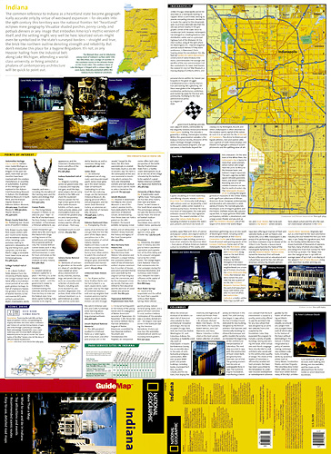
Mapa samochodowa wodoodporna jednego z amerykańskich stanów wydana przez National Geographic USA
Dodatkowo zawiera:
plany miast
indeks miejscowości
opisy
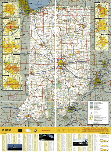
in a series of US state maps from the National Geographic with cartography from Mapquest, including city maps of Indianapolis with a downtown enlargement, Bloomington, Elkhart, Evansville, Fort Wayne, Lafayette, Muncie, South Bend and Terre Haute, plus a scenic drive route along the Ohio River. The map is laminated and waterproof.
Maps in the NGS State Series clearly show each state’s national parks, forests and other protected areas, with topography indicated by subtle relief shading and plenty of names of mountain ranges, valleys, deserts, etc. Indian Reservations are also marked and various places of interest are highlighted, including historical or natural sites, visitor information centres, campsites, etc.
| Rok wydania: | 2003 |
| Kod kreskowy: | 9780792235651 |
| Język: | ANGIELSKI |
| Ilość stron: | 2 |
| Wymiary: | 23 x 10.5 cm |
| Okładka / oprawa: | miękka wodoodporna |
-
Promocja P

MIAMI mapa/ plan miasta PopOut Maps
MIAMI mapa/ plan miasta PopOut Maps14,99PLNStara cena 19,99Dodaj do koszykadodano produktprodukt niedostępny -
Promocja PPolecany P

AMERYKA PÓŁNOCNA składana mapa polityczna 1:8 000 000 FREYTAG & BERNDT
AMERYKA PÓŁNOCNA składana mapa polityczna 1:8 000 000 FREYTAG & BERNDT59,90PLNStara cena 79,90Dodaj do koszykadodano produktprodukt niedostępny -
Nowość N Promocja PPolecany P

ŚWIAT POLITYCZNY I FIZYCZNY mapa 1:20 000 000 FREYTAG & BERNDT 2023
ŚWIAT POLITYCZNY I FIZYCZNY mapa 1:20 000 000 FREYTAG & BERNDT 202354,90PLNStara cena 59,90Dodaj do koszykadodano produktprodukt niedostępny -
Nowość N Promocja PPolecany P

AMERYKA PÓŁNOCNA ŚRODKOWA KARAIBY mapa wodoodporna NATIONAL GEOGRAPHIC 2022
AMERYKA PÓŁNOCNA ŚRODKOWA KARAIBY mapa wodoodporna NATIONAL GEOGRAPHIC 202269,90PLNStara cena 79,90Dodaj do koszykadodano produktprodukt niedostępny -

US KANADA BORDER mapa 1:2 500 000 ITMB
36,90PLNDodaj do koszykadodano produktprodukt niedostępny -
Promocja P

WIELKIE JEZIORA Great Lakes mapa samochodowa 172 MICHELIN
WIELKIE JEZIORA Great Lakes mapa samochodowa 172 MICHELIN29,90PLNStara cena 44,90Dodaj do koszykadodano produktprodukt niedostępny