
690990688
geograf.biuro@gmail.comSzanowni klienci, w trakcie zakupów prosimy o zwrócenie uwagi na czas realizacji zamówienia poszczególnego produktu, znajdujący sie pod ceną produktu.
Kategorie
Producenci


BANF MOUNT ASSINIBOINE mapa 1:100 000 GEM TREK 2020

| Producent: GEM TREK |
| Kod EAN: 9781895526981 |
")
")
")
BANF - MOUNT ASSINIBOINE
mapa turystyczna w skali 1:100 000
GEM TREK 2020
Waterproof and tear-resistant hiking and recreation map for the Banff and Mount Assiniboine regions of the Canadian Rockies
Gem Trek's Banff & Mount Assiniboine map is designed for outdoor enthusiasts looking to explore the southern portion of Banff National Park and Mount Assiniboine Provincial Park. Whether you are touring along the roads or heading into the backcountry of Mount Assiniboine, you'll find the waterproof and tear-resistant Banff & Mount Assiniboine map to be an invaluable tool.
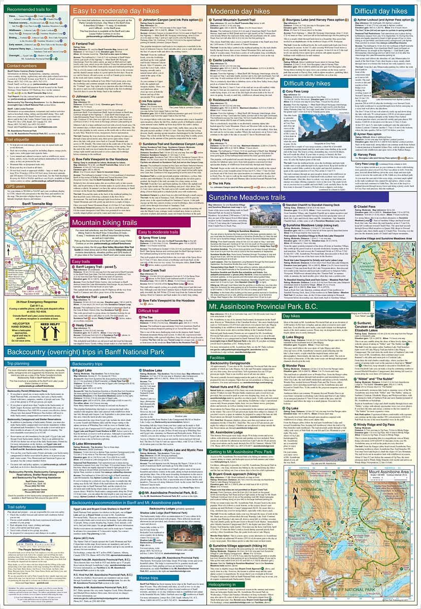
This map features detailed cartography, accurate hiking trails with distances, and details such as campgrounds, picnic areas, and lookouts. On the back are descriptions of the most popular hiking trails, including detailed descriptions of all access routes into Mount Assiniboine Provincial Park.This waterproof and tear-resistant map features detailed cartography, accurate hiking trails with distances, and details such as campgrounds, picnic areas, and lookouts. On the back are descriptions of the most popular hiking trails, including detailed descriptions of all access routes into Mount Assiniboine Provincial Park.
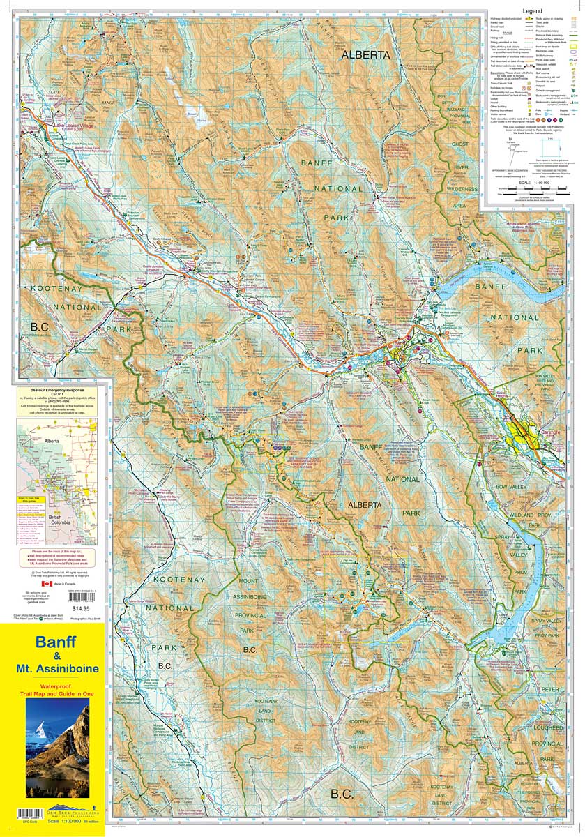
The Banff & Mount Assiniboine map covers the southern portion of Banff National Park from Lake Louise in the north. It also includes the southern portion of the remote eastern region of Banff National Park, including trails through the remote Johnston Creek, Cascade, and Forty Mile Valleys. Popular hiking trails on the Banff & Mount Assiniboine map include Arnica Lake, Twin Lakes, Johnston Canyon, Shadow Lake, Bourgeau Lake, Sunshine Meadows, Cascade Amphitheatre, Aylmer Pass, and Spray River Loop. This map is particularly useful for visitors heading to Mount Assiniboine Provincial Park (British Columbia), which is only accessible by hiking trail or helicopter. The front of the map includes coverage of all hiking trails leading into Mount Assiniboine, including from Mount Shark, Sunshine Meadows, and Highway 93.
A 1:50,000-scale inset map on the back increases coverage of Mount Assiniboine Provincial Park, with day hikes from Lake Magog including to Wonder Pass, Windy Ridge, The Nub, and Sunburst Valley.
The Banff & Mount Assiniboine Map features:
- waterproof and tear-resistant paper
- contour lines at 25-metre (80-foot) intervals
- relief shading to better show the topography
- full colour on both sides
- hiking trails with trail names and trail distances marked
- mountain biking trails with trail names and distances marked
- hydrology rivers, rapids and waterfalls
- mountain names and all available mountain elevations
- all campgrounds
- points of interest and attractions
- picnic areas
- highway viewpoints
| Autor: | praca zbiorowa |
| Producent/Wydawnictwo: | GEM TREK |
| Rok wydania: | 2020 |
| Kod kreskowy: | 9781895526981 |
| Skala mapy / planu miasta: | 1:100 000 |
| Język: | angielski |
| Ilość stron: | 2 |
| Wymiary: | 10 x 25 cm |
| Okładka / oprawa: | miękka |
| Numer wydania: | 9 |
-
Promocja P

MIAMI mapa/ plan miasta PopOut Maps
MIAMI mapa/ plan miasta PopOut Maps14,99PLNStara cena 19,99Dodaj do koszykadodano produktprodukt niedostępny -
Promocja PPolecany P

AMERYKA PÓŁNOCNA składana mapa polityczna 1:8 000 000 FREYTAG & BERNDT
AMERYKA PÓŁNOCNA składana mapa polityczna 1:8 000 000 FREYTAG & BERNDT59,90PLNStara cena 79,90Dodaj do koszykadodano produktprodukt niedostępny -
Nowość N Promocja PPolecany P

ŚWIAT POLITYCZNY I FIZYCZNY mapa 1:20 000 000 FREYTAG & BERNDT 2023
ŚWIAT POLITYCZNY I FIZYCZNY mapa 1:20 000 000 FREYTAG & BERNDT 202354,90PLNStara cena 59,90Dodaj do koszykadodano produktprodukt niedostępny -
Nowość N Promocja PPolecany P

AMERYKA PÓŁNOCNA ŚRODKOWA KARAIBY mapa wodoodporna NATIONAL GEOGRAPHIC 2022
AMERYKA PÓŁNOCNA ŚRODKOWA KARAIBY mapa wodoodporna NATIONAL GEOGRAPHIC 202269,90PLNStara cena 79,90Dodaj do koszykadodano produktprodukt niedostępny -

US KANADA BORDER mapa 1:2 500 000 ITMB
36,90PLNDodaj do koszykadodano produktprodukt niedostępny -
Promocja P

WIELKIE JEZIORA Great Lakes mapa samochodowa 172 MICHELIN
WIELKIE JEZIORA Great Lakes mapa samochodowa 172 MICHELIN29,90PLNStara cena 44,90Dodaj do koszykadodano produktprodukt niedostępny