
690990688
geograf.biuro@gmail.comSzanowni klienci, w trakcie zakupów prosimy o zwrócenie uwagi na czas realizacji zamówienia poszczególnego produktu, znajdujący sie pod ceną produktu.
Kategorie
Producenci


TIEN SHAN KIRGISTAN cz. zachodnia INYLCHEK mapa terkkingowa Alpenverein

| Producent: Alpenverein |
| Kod EAN: 9783937530024 |
")
")
")
")
")
0/14 TIEN SHAN KIRGISTAN
cz. zachodnia
INYLCHEK
mapa terkkingowa
Alpenverein
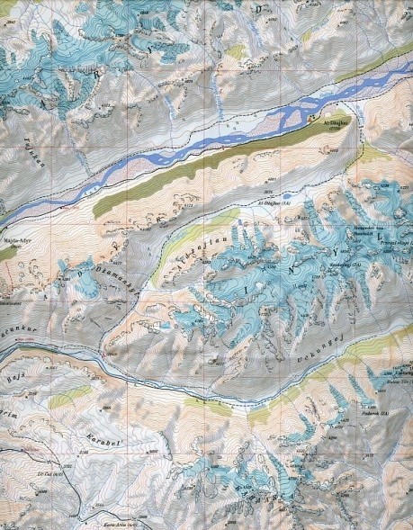
Exceptionally detailed and informative topographic map at 1:100,000 of the Inylchek area in the Tien Shan Mountains in Kyrgyzstan, prepared by the German Alpine Club using data from the Kyrgyz national survey organization plus satellite imagery.
Topography is shown by contours at 50m intervals with relief shading, plus numerous spot heights and peak names. Colouring and graphics indicate different types of vegetation (woods, meadows, swampy grassland, etc.) and soil cover (rocky outcrops, individual isolated rocks with height, caves, moraine, glaciers, etc.). Passes are classified according to the difficulty of traverse. Rivers and creeks indicate their width.
The map shows local roads (paved, country lanes, dirt roads and forest tracks) and footpaths, as well as settlements and isolated buildings, bridges passable by vehicles or on foot, fuel and water tanks, etc. Assent and descent routes, base camp and possible camp sites are highlighted. The map has a UTM grid with latitude and longitude margin ticks at 5' intervals. Map legend is in English, German and Russian. Also included are tri-lingual notes on using this map with GPS units.
| Autor: | PRACA ZBIOROWA |
| Producent/Wydawnictwo: | Alpenverein |
| Rok wydania: | 2008 |
| Kod kreskowy: | 9783937530024 |
| Skala mapy / planu miasta: | 1:100 000 |
| Język: | NIEMIECKI |
| Ilość stron: | 2 |
| Wymiary: | 21 x 13 cm |
| Okładka / oprawa: | miękka w plstikowym etui |
-
Promocja P

TYBET Mount Everest, Shigatse, Lhasa, Namtso laminowana mapa trekkingowa terraQuest EXPRESSMAP
TYBET Mount Everest, Shigatse, Lhasa, Namtso laminowana mapa trekkingowa terraQuest EXPRESSMAP36,90PLNStara cena 59,90Dodaj do koszykadodano produktprodukt niedostępny -
Promocja PPolecany P

AZJA składana mapa polityczna 1:9 000 000 FREYTAG & BERNDT 2022
AZJA składana mapa polityczna 1:9 000 000 FREYTAG & BERNDT 202266,90PLNStara cena 79,90Dodaj do koszykadodano produktprodukt niedostępny -
Promocja P

HIMALAJE INDYJSKIE laminowana mapa trekkingowa 1:350 000 EXPRESSMAP
HIMALAJE INDYJSKIE laminowana mapa trekkingowa 1:350 000 EXPRESSMAP54,90PLNStara cena 54,90Dodaj do koszykadodano produktprodukt niedostępny -
Promocja PPolecany P

AZJA ŚRODKOWA UZBEKISTAN KIRGISTAN TADŻYKISTAN TURKMENISTAN mapa 1:1 700 000 REISE KNOW HOW 2020
AZJA ŚRODKOWA UZBEKISTAN KIRGISTAN TADŻYKISTAN TURKMENISTAN mapa 1:1 700 000 REISE KNOW HOW 202044,90PLNStara cena 49,90Dodaj do koszykadodano produktprodukt niedostępny -
Nowość N Promocja PPolecany P

ŚWIAT POLITYCZNY I FIZYCZNY mapa 1:20 000 000 FREYTAG & BERNDT 2023
ŚWIAT POLITYCZNY I FIZYCZNY mapa 1:20 000 000 FREYTAG & BERNDT 202354,90PLNStara cena 59,90Dodaj do koszykadodano produktprodukt niedostępny -
Nowość N Promocja PPolecany P

AZJA mapa wodoodporna NATIONAL GEOGRAPHIC 2022
AZJA mapa wodoodporna NATIONAL GEOGRAPHIC 202269,90PLNStara cena 79,90Dodaj do koszykadodano produktprodukt niedostępny -

AZJA POŁUDNIOWO - WSCHODNIA mapa 1:4 000 000 ITMB
39,90PLNDodaj do koszykadodano produktprodukt niedostępny -
Promocja PPolecany P

BHUTAN mapa samochodowa 1:250 000 REISE KNOW HOW 2019
BHUTAN mapa samochodowa 1:250 000 REISE KNOW HOW 201944,90PLNStara cena 49,90Dodaj do koszykadodano produktprodukt niedostępny -

AZJA ŚRODKOWA mapa samochodowa 1:2 400 000 ITMB
39,90PLNDodaj do koszykadodano produktprodukt niedostępny